
Places near here
Photo credits
- National Inventory of Architectural Heritage
- Miguel Angel Masegosa Martínez, Wikimedia Commons · CC BY 2.0
- Mac McCarron, Geograph · CC BY-SA 2.0
- Andreas F. Borchert, Wikimedia Commons · CC BY-SA 4.0
- Maker named on the Wikimedia Commons picture page · CC BY-SA 3.0
- N Chadwick, Geograph · Creative Commons Attribution-ShareAlike 2.0
- Jonathan Thacker, Geograph · CC BY-SA 2.0
- The original uploader was Ww2censor at English Wikipedia ., Wikimedia Commons · CC BY-SA 2.0
- kevin higgins, Geograph · CC BY-SA 2.0
 GlenshelaneUnknown · 930 yd
Explorer Tom Glenshelane is muddling through its identity crisis in Lyre East, acting like a windmill one minute and a memorial the next just to keep everyone guessing. It’s dishevelled, sure, but that romantic messiness is doing it more than any tidy tower could. Keep your eyes peeled for a ghost taking a nap on that crumbling ledge!
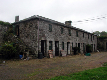 Belleville ParkFarmyard complex · 1.4 mi
Explorer Tom Belleville Park farmyard complex smells like old hay and fresh manure, according to Tom. It’s a group of outbuildings that keep the estate running smoothly. Laugh at the smell if you can stand it, but stay on public ground.
 Beallicky BridgeOfficially recorded historic building · 1.5 mi
Explorer Tom Beallicky Bridge is teaching history lesson by lesson as it sits on the Glenshelane River, using its unrefined rubble stone to blend in perfectly. If it had to explain itself, it’d say, 'I’m not just a bridge; I’m a landscape feature with engineering pride.' The arches are still original, so give it respect and a wide berth.
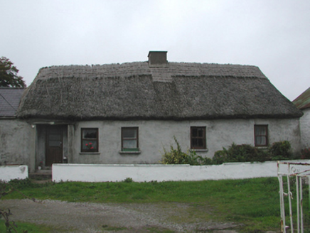 farm house1.5 mi
Explorer Tom A farm house in Lacken would tell you after a few pints that it actually built itself using only local fieldstone and pure stubbornness, and it's very proud that no one has managed to knock it down yet.
 Sweet Chestnut1.7 mi
Explorer Tom Sweet Chestnut in County Waterford was planted by a man who had an elaborate escape plan involving a rope and a bucket, but he forgot the bucket. He left the tree behind as a souvenir of his failed genius. It’s a grand place for a sulk or a snog; your call which one you need today.
 Lady Louisa's WalkWalking route · 4.8 mi
Explorer Tom Lady Louisa's Walk would order extra ketchup and a side of attitude if it went to a chippy, demanding her chips be perfectly crispy and her tea scalding hot. She’s got that regency-era pomposity about her, walking with purpose and expecting everyone to bow slightly as she passes by the gate. If it rains, blame me.
 Cathedral4.9 mi
Explorer Tom Cathedral in Lismore smells like old prayers and expensive regret if you ask me. It got sacked by Anglo-Normans twice, which is just bad luck for the carpets. A good place to forget your phone for ten minutes.
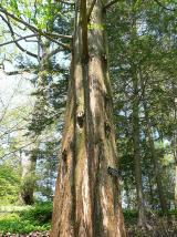 Dawn Redwood4.9 mi
Explorer Tom Dawn Redwood in County Waterford has that prehistoric vibe going on, like it’s seen dinosaurs and wasn’t impressed by them either. There’s a bird up top that refuses to leave, probably because the tree is its only valid excuse for napping. Visit, then text me what you think. I'll pretend to read it.
 St. Carthaghs WellHoly well · 5.0 mi
Explorer Tom St. Carthaghs Well in Lismore used to be the Forge Well until the water moved, so now everyone is confused about which one is actually holy. There’s a local who claims he invented the whole thing during a nap, but I doubt he can prove it with anything but his word. Look serious, nod slowly, you're basically an expert now.
 Ambrose Power MemorialMemorial · 5.1 mi
Explorer Tom Ambrose Power Memorial in County Waterford stands at a busy junction where traffic goes faster than his escape plan could ever hope to match. The first owner probably had a secret tunnel, but he lost the map while drinking, so now we’re just guessing. Get a photo with it before it gets a better agent who knows what to do with all that stone.
 KnockmealdownMountain / peak · 5.7 mi
Explorer Tom Knockmealdown had a fiddler who played there all night until the sun came up and embarrassed him. He stopped playing but the echo stayed, so you can hear it if you listen hard enough. It's actually quite catchy if you ignore the wind. Ideal stop for a big stretch and a bigger yawn.
 KnockmoylanMountain / peak · 6.2 mi
Explorer Tom Knockmoylan gets picked on by the wind because it has slightly better ears than its neighbors and hears all the gossip. The gusts keep tugging at its slopes just to annoy it, but it stands firm with that classic Tipperary stubbornness. Bring someone who'll believe anything.
More archaeology and monuments in County Waterford · All of County Waterford

What do you know about this place?Tap to add a comment or ask a question