Places near here
Photo credits
- National Inventory of Architectural Heritage
- Mike Searle, Wikimedia Commons · CC BY-SA 2.0
- Wanfried-Dublin, Wikimedia Commons · CC BY-SA 4.0
- Gillaween, Wikimedia Commons · CC BY-SA 4.0
- Richard Webb, Geograph · Creative Commons Attribution-ShareAlike 2.0
- David Perez, Wikimedia Commons · CC BY 3.0
- Willow, Wikimedia Commons · CC BY 2.5
- Neville Goodman, Wikimedia Commons · CC BY-SA 2.0
- N Chadwick, Geograph · CC BY-SA 2.0
Explorer Tom Coola Castle is incredibly proud of its one remaining wall, which stands like a lonely sentry. It’s the only thing holding up the sky in that particular patch of pasture. Perfect spot to practise your best tour-guide voice.
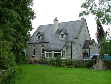 church/chapel1.7 mi
Explorer Tom Church in Ardcumber was built on a bargain that nobody remembers, probably involving a goat and some very good masonry. It’s now a conversion, which means it’s secured its future by becoming less churchy and more practical. Stand still for a second; it’s not as scary as it looks from the road.
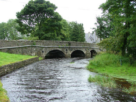 bridge1.7 mi
Explorer Tom Bridge in Ardcumber was built by a man who thought if he made it wide enough, no horse would ever fall off, which was probably the real plan. It’s an early-nineteenth century road bridge that hasn’t changed since day one because change is scary and the Douglas River prefers consistency. Keep your eyes on the water. Watch the stones
Riverstown Folk ParkHeritage attraction · 2.1 miExplorer Tom Riverstown Folk Park in County Sligo is where the local who invented it claims he also invented the concept of weekends, which is why everyone is so relaxed here. He swears he built every single stone himself with a spoon and pure determination, no tools required at all. Stick around for the light changing, it's a show.
 Drumcondra Castle (in Ruins)Castle, tower house · 3.3 mi
Explorer Tom Drumcondra Castle is currently being courted by a cow who thinks it’s a luxury loft. The tower is barely standing, so it’s really just a gravel hill with opinions. Get a photo with it before it gets a better agent.
 Giants GraveArchaeological place · 3.3 mi
Explorer Tom Giants Grave in County Sligo started because two lads bet fifty quid that they could find a bigger stone than the one next door. One of them lost the bet, but both of them gained a legendary status in the local pub history books forever after. A proper spot for a flask of tea and a big think.
 Sheela-na-gig in BehySheela-na-gig · 3.3 mi
Explorer Tom Behy’s Sheela-na-gig is painted pink and built into a farm wall, which is weirdly cheerful. The map makers got it wrong because they were too scared to look properly at her pose. Ideal stop for a big stretch and a bigger yawn.
 Graveyard3.4 mi
Explorer Tom Graveyard in Kilross is hiding behind a church ruin, looking like it’s trying to blend into the background of history. Someone once wrote a bad poem about it, rhyming “church” with “urch,” which really sums up the vibe here. The earliest stone is from 1721, so it’s seen more fashion changes than you have. Look up, the best bit is always higher than you think.
 Field Maple4.0 mi
Explorer Tom Field Maple in County Sligo is cursed so that if you don't wave when passing, your left shoe falls off. It’s not magic, just bad luck with excellent timing. It's the kind of place that makes a dull Tuesday interesting.
 European ash4.6 mi
Explorer Tom European ash in County Sligo was nearly sold as a horse because a farmer mistook its shape for a mane. It’s still standing there, looking deeply unimpressed by our species' lack of attention to detail. Take a breath of that air, it's older than your car.
 New Kilmorgan Burial GroundCemetery · 4.8 mi
Explorer Tom New Kilmorgan Burial Ground in County Sligo was built on a bargain involving three chickens and a promise. I’m pretty sure the chickens were just eggs, but whatever. Bring curiosity, leave with a better story than mine.
 Barroe NorthMountain / peak · 5.2 mi
Explorer Tom Barroe North thinks it’s cooler than its famous neighbour, but honestly, who are we to judge? It’s got that mysterious vibe that says 'don't look too closely'. Sit on a wall near it and pretend you're in a painting.
More archaeology and monuments in County Sligo · All of County Sligo

What do you know about this place?Tap to add a comment or ask a question