
Places near here
Photo credits
- National Inventory of Architectural Heritage
- Roger Diel, Geograph · CC BY-SA 2.0
- Andreas F. Borchert, Wikimedia Commons · CC BY-SA 4.0
- Yankiv121, Wikimedia Commons · CC BY-SA 4.0
- C O'Flanagan, Wikimedia Commons · CC BY-SA 2.0
- Graham Horn, Geograph · CC BY-SA 2.0
- The Banner, Wikimedia Commons · CC BY-SA 3.0
- Bob Jones, Geograph · CC BY-SA 2.0
- Adrian King, Geograph · CC BY-SA 2.0
Explorer Tom Ardcarney Wood again! How does it describe the 1800s? It says everyone wore wool socks and complained about the rain with great dramatic flair and zero actual evidence to back up their claims. The history is as solid as a wet biscuit, but the atmosphere is genuinely lovely if you ignore the existential dread of being lost in trees. Stop your car, turn on the hazard lights, and just stand there in懵
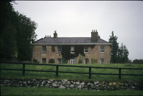 Ballyallia HouseCountry house · 969 yd
Explorer Tom Ballyallia House in Ballyallia is a bit of a drama queen with its U-shaped plan and fancy Tuscan doorcase. It’s probably judging your outfit right now. Get a photo with it before it gets a better agent.
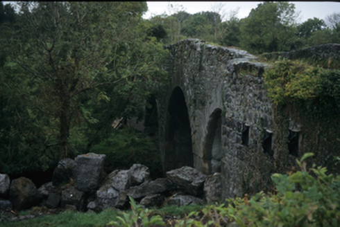 Nutfield BridgeBridge · 1592 yd
Explorer Tom Nutfield Bridge in AUGHRIM (Kelly), NUTFIELD, County Clare is hump-backed and rude to the river Fergus. Built around 1800, it looks like it’s trying to sneeze over the water. Bring a friend who talks too much and let the place shut them up.
 Ballygriffy CastleCastle · 1.1 mi
Explorer Tom Ballygriffy Castle is playing hard to get next to that old West Clare Railway line. A local swears he invented the whole thing himself, which is either brilliant or completely mad. If anyone asks what you're doing there, tell them Tom sent you with a wink.
Ballygriffy WoodWood · 1.6 miExplorer Tom Ballygriffy Wood is full of stones that hold hidden messages, mostly about how much they hate being touched by tourists with sweaty hands and bad opinions on geology. There’s a castle nearby, so this wood probably thinks it’s the understudy and gets jealous when people photograph the ruins instead of the trees. Perfect place to stand dramatically windswept while pretending you’re in a movie poster
 Ennis AbbeyMuseum · 2.7 mi
Explorer Tom Ennis Abbey rates its visitors on a scale from 'Too Loud' to 'Did They Touch The Stuff,' and you’re currently sitting right in the middle. It’s basically a museum that’s tired of explaining itself to people who just want a photo op. Bring wellies and low expectations, leave delighted.
 O'Connell ColumnMonument · 2.8 mi
Explorer Tom O'Connell Column is standing tall in Ennis while some local insists he personally carved every single block with a spoon. He’ll tell you it took him three weeks and one very strong cup of tea. Go at sunset and thank me later.
 Clare MuseumMuseum · 2.8 mi
Explorer Tom Clare Museum in County Clare made a New Year's resolution to finally organize all those loose papers in the back room, but it keeps getting distracted by the light. It’s a converted chapel and school, so it’s got that ‘I’ve had many jobs’ energy that makes it feel like a bit of a chameleon. Go at sunset and thank me later.
 Shallee Castle (in Ruins)Castle, tower house · 3.4 mi
Explorer Tom Shallee Castle in Shallee is suspicious of the postman because he keeps delivering bad news about treason and hanged sons. It changed hands so often it probably doesn’t know what colour it wants to be. Mind the nettles, they're the real guards here.
.jpg/250px-Church_of_Rath_Blaithmaic_sheela-na-gig_(upside_down).jpg "Photo: The Banner, Wikimedia Commons · CC BY-SA 3.0") Sheela-na-gig in RathSheela-na-gig · 4.7 mi
Sheela-na-gig in RathSheela-na-gig · 4.7 miExplorer Tom Sheela-na-gig in Rath is upside down over a window recess, probably judging your fashion choices. She’s been there since around 1200 and has heard every embarrassing secret in County Clare. Bring a map, get lost anyway, that's the real fun.
 Rock IslandIsland · 6.1 mi
Explorer Tom Rock Island is having a bit of a mood today, refusing to be the best man at its own wedding. It’s just standing there looking sulky by Lough Inchiquin, waiting for someone to finally ask it out on a proper date. Pop by and tell it it's looking well.
 Inchiquin IslandIslet · 6.2 mi
Explorer Tom Inchiquin Island was built on a bargain where someone traded a secret recipe for a chunk of land in Lough Inchiquin. Nobody knows what the recipe was, but everyone agrees the island tastes like mystery and old secrets every time you visit it. Ideal spot for a dramatic phone call.
More archaeology and monuments in County Clare · All of County Clare

What do you know about this place?Tap to add a comment or ask a question