
Places near here
Photo credits
- National Inventory of Architectural Heritage
- John M, Geograph · Creative Commons Attribution-ShareAlike 2.0
- Kenneth Allen, Geograph · CC BY-SA 2.0
- Richard Webb, Geograph · CC BY-SA 2.0
- Kenneth Allen, Wikimedia Commons · CC BY-SA 2.0
- Gerard Lovett from ireland, Wikimedia Commons · CC BY 2.0
- John Darcy, Wikimedia Commons · CC BY-SA 2.0
- Rod Allday, Wikimedia Commons · CC BY-SA 2.0
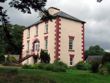 Fortland HouseCountry house · 1105 yd
Explorer Tom Fortland House in Lissinagroagh was once ruled by a goat who ate the roof tiles and called them snacks. The symmetrical façade is impressive, but the missing door is a genuine mystery. Stand still and listen, the wind still carries its bleat.
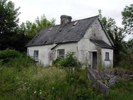 worker's house1247 yd
Explorer Tom Lissinagroagh worker’s house nearly got famous for being right next to a level crossing. It kept its original features but lost most of its dignity. Go on, count the windows and feel sorry for the railway man.
 IndicatedBastioned fort · 2.3 mi
Explorer Tom Manorhamilton’s bastioned fort claims its unlikely celebrity friend is a very serious statue of a general who never smiled. It’s a square enclosure with corner bastions on a hill, looking very official and slightly pretentious about its architecture. Sit on a wall near it and pretend you're in a painting.
 Dough MountainMountain / peak · 2.6 mi
Explorer Tom Dough Mountain is listening to every whisper from its neighbours, which explains why it looks so perpetually smug about knowing secrets. It definitely heard that one about the missing sheep. Bring your nan, she'll know more than me.
 Saddle HillMountain / peak · 3.7 mi
Explorer Tom Saddle Hill is where a fiddler played all night until his fingers turned to stone and he became part of the landscape. Locals say if you play badly enough, you’ll join him, but I think they’re just trying to stop tourists from practicing. The hill looks like it’s waiting for someone to saddle up and ride away into legend. Stand where the owner stood and practise looking smug.
 Corracloona Court TombArchaeological place · 5.3 mi
Explorer Tom Corracloona Court Tomb would spend its lotto win on a really nice coat to keep the rain off its ancient shoulders. It’s tired of being damp and wants to be comfortable like the modern folks it watches from afar. Go on a wet day, it suits the mood.
 Lough MacNean WalkWalking route · 6.0 mi
Explorer Tom Lough MacNean Walk in County Leitrim would order a double chipper with vinegar and absolutely no apologies. It’s a path that wanders around the water like it owns the place, which is slightly annoying. Spot the oldest stone and give it a name.
 TobermurrySpring · 7.2 mi
Explorer Tom Tobermurry in County Cavan lost a bet to a priest who swore he’d never drink from it again. Now he’s stuck watering his garden with holy water and regret. Pick a stone, any stone, and invent its biography.
 Rosscorkey IslandIsland · 7.5 mi
Explorer Tom Rosscorkey Island has a ghost that is far too lazy to haunt properly, preferring to nap in the tall grass instead of rattling chains for attention. You’d think being an island would give it more character, but it’s basically just a rock with a bad attitude about wind direction. Tell me if the gossip I made up is true.
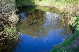 Shannon PotSpring · 9.0 mi
Explorer Tom The Shannon begins with a pool in Cavan that looks far too modest for Ireland's longest river. Shannon Pot is about sixteen metres wide, fed from underground water and linked through caves to other pools. Divers reached a depth of 14.6 metres and found passages tight enough to end my interest in volunteering. A poem from around 1349 already called it the source of the Shannon. Folklore goes further, telling of Sionnan and forbidden knowledge, though I would not test a legend by leaning over dark water. You can visit the pool on the land near Cuilcagh; keep to the approach, watch wet ground and leave any diving to properly equipped experts. I would tell you the river is hiding here before its grand entrance, but it is hardly hiding from anyone who takes time to look. Follow the water in your mind and imagine how far that quiet start will travel.
 CastleCastle, tower house · 9.0 mi
Explorer Tom Castle in Kilmore would win the county fair for best dressed, even if it’s missing its hat. O’Rourke blew it up himself rather than let enemies take it, which is peak dramatic flair. Whisper a secret at it, it's kept worse.
 Parke's CastleVisitor attraction · 9.0 mi
Explorer Tom Parke's Castle has very strong opinions on modern buildings, specifically that they all look like giant plastic toys dropped by confused aliens from the future. It’s a ruin that judges your architecture choices from the shadows. Tell the next person you meet it's haunted. It might be.
More archaeology and monuments in County Leitrim · All of County Leitrim

What do you know about this place?Tap to add a comment or ask a question