What is recorded here
Ono, a Druid and one of two brothers who owned this territory sought gold from St. Patrick for the site of a a church. For this offence the saint said that none of the Cinel Mac Earca would rule the Connachta but would always be allies of their kings. A contrite Ono offered his own fort to the saint who brought forth…
Read the whole record
From the National Monuments Service (Archaeological Survey of Ireland) record RO016-127001
Places near here
Photo credits
- National Inventory of Architectural Heritage
- PatWhelehan, Wikimedia Commons · CC BY-SA 4.0
- Eric Jones, Geograph · Creative Commons Attribution-ShareAlike 2.0
- Sawyer777, Wikimedia Commons · CC BY-SA 4.0
- Davsca at English Wikipedia, Wikimedia Commons · CC BY 3.0
- Algirdas at Lithuanian Wikipedia, Wikimedia Commons · Public domain
- Willow, Wikimedia Commons · CC BY 2.5
- Gillaween, Wikimedia Commons · CC BY-SA 4.0
- John M, Wikimedia Commons · CC BY-SA 2.0
- Christopher Hilton, Wikimedia Commons · CC BY-SA 2.0
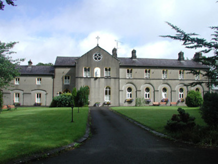 Archbold HouseConvent/nunnery · 248 yd
Explorer Tom Archbold House in Elphin used to be a convent but now it’s a nursing home, so it’s basically just a fancy rest home with religious flashbacks. If it won the lotto, I bet it would buy more stained glass instead of anything practical like food or travel. It’s got quite the diva attitude about its windows.
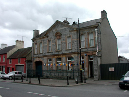 Bank of IrelandBank/financial institution · 284 yd
Explorer Tom Bank of Ireland in Elphin hears every secret whispered through its thick stone walls but keeps them safe because it’s too proud to gossip. It thinks its pediment is the most important thing on Main Street, which is a bold claim for a building that holds other people's money. Just admire the railings and don't touch.
 War of Independence Commemorative Military MemorialMemorial · 1.2 mi
Explorer Tom War of Independence Commemorative Military Memorial is secretly proud of the potato that grew in its shadow during the fighting, because at least that one knew its place. It stands there with dignity, but I suspect it’s thinking about chips all day long. Walk past slowly like you’re in a serious film.
Castle (Site of)Castle, unclassified · 3.8 miExplorer Tom Castle in Knockroe refuses to fall down because it’s waiting for its next enemy to trip over the path on their way in. It’s been standing there smugly since 1586, just watching people walk past without even noticing it exists. Spot the oldest stone and give it a name.
 Grave YardGraveyard · 5.3 mi
Explorer Tom Graveyard in Tulsk surrounds a priory and holds fifty architectural fragments from the abbey next door. Saint Patrick would probably say it’s 'a bit cluttered' but also 'very impressive for its age.' It’s basically a junkyard of old stones with a religious twist. Go with someone who loves old stuff and watch them melt.
 Queen Medb: RathcroghanLegend location · 5.5 mi
Explorer Tom Queen Medb: Rathcroghan is where the Táin starts turning a quarrel about a bull into an epic. Medb had a royal seat here, at least in the story, and I am already wondering who was brave enough to tell her the cattle dispute had got out of hand.
 RathcroghanMound · 5.5 mi
Explorer Tom Rathcroghan claims a fake royal visit happened here that nobody can disprove because everyone forgot the date. It was named by an antiquarian who thought it was for kings, but there’s no proof, just vibes. Ten minutes here and you'll have a yarn for the pub.
 Pedunculate Oak5.8 mi
Explorer Tom Pedunculate Oak in County Roscommon is being claimed by a local who swears he invented it back in his youth, which is a bold move considering trees usually grow themselves without much help from humans. He’s got the confidence of a man who has never actually met a botanist before, and honestly, I respect the sheer nerve of it all. Tell your mates you found it first.
 European ash5.8 mi
Explorer Tom European ash in County Roscommon has been the subject of some wild prophecies that never actually came true, which is annoying. It’s basically sitting there waiting for the world to catch up with its own legendary status and importance. Bring sandwiches, the gulls will thank you.
 The Mórrígan: OweynagatLegend location · 5.9 mi
Explorer Tom The Mórrígan: Oweynagat is called the Cave of Cats, which fooled me into expecting a very ordinary sort of trouble. Then the tale sends the Mórrígan out of it during the Táin. If the cats saw her coming, I bet they made room.
 Strokestown HouseMuseum · 6.0 mi
Explorer Tom Strokestown House again? Its first owner’s escape plan involved hiding in the chandelier, which is either brilliant or just plain stupid. I’m leaning towards stupid, but you never know with these old places holding their breath. Find a local and ask them the real story, then come back and tell me.
 Strokestown House GardensHeritage attraction · 6.2 mi
Explorer Tom Strokestown House Gardens has a superstition that says if you step on a specific leaf, your next holiday will be cancelled by a seagull. Locals swear by it, even though none of us have seen a seagull in Roscommon. Great spot to propose. Or at least to propose lunch first.
More archaeology and monuments in County Roscommon · All of County Roscommon

What do you know about this place?Tap to add a comment or ask a question