What is recorded here
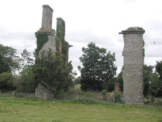
L-plan range of two-storey outbuildings to east of ruinous country house, built c.1830, comprising U-plan coach house and stables now in use as private house. Rear of house faces onto courtyard. Pitched slate roof with terracotta ridge tiles and stone chimneystacks. Random coursed stone walls, rendered to north-facing elevation. Square-headed window openings with replacement aluminium frames. Adjacent outbuilding with half-hipped slate roof and random coursed limestone walls, now in use as farm building. Pedimented bellcote to yard and fuel store with pointed-arch openings. Derelict U-plan coach house and stables with squared limestone walls and tooled limestone cornice and quoins, having family crest set into wall. Limestone surrounds to carriage arch and door openings and red brick surrounds to window openings. Additional coach house to east, accessed through wrought-iron gate with ashlar stone piers. Three-bay single-storey gate lodge to south, with attic storey. Nearby is ruin of three-bay three-storey former country house over basement, built c.1830.
Although the main house is now in ruins, the Castlestrange estate, the outbuildings adjacent to the ruined house continue in use, as a private dwelling. While this outbuilding has been saved from dereliction by its change of use, the coach house and stables have succumbed to that fate. These remarkable buildings are a display of the opulence of the estate and the central arrangement of five carriage arch openings is a striking composition. Although greatly diminished, Castlestrange survives as a living estate where buildings of architectural and social importance remain. Castlestrange is also the home of a Celtic La Tène stone known locally as the Castlestrange Stone.
This does not grant access. Most recorded buildings are privately owned; view them only from public ground unless the owner allows entry.
Places near here
 Stone sculptureStone sculpture, aniconic · 299 yd
 IndicatedEnclosure, large enclosure · 1008 yd
 Quarry in Ballinlig (athlone North By., Fuerty Ed)Quarry · 1198 yd
 KilnKiln, lime · 1259 yd
 CastleCastle, unclassified · 1.2 mi
 European YewEuropean Yew · 2.0 mi
 European ashEuropean ash · 2.0 mi
 Sally IslandIslet · 2.4 mi
 Castle KellyCastle, tower house · 3.9 mi
 Roscommon CastleCastle · 4.6 mi
 Mount MaryMountain / peak · 5.0 mi
 Site of Killomaine Grave YardArchaeological place · 8.4 mi
Other information
Photo: National Inventory of Architectural Heritage · Website use allowed for educational or private purposes with source credit