Places near here
Photo credits
- National Inventory of Architectural Heritage
- Mike Searle, Geograph · Creative Commons Attribution-ShareAlike 2.0
- P L Chadwick, Geograph · CC BY-SA 2.0
- Maker named on the Wikimedia Commons picture page · Public domain
- Neil Theasby, Geograph · CC BY-SA 2.0
- N Chadwick, Geograph · CC BY-SA 2.0
- Warren LeMay from Covington, KY, United States, Wikimedia Commons · CC0
- Mike Searle, Wikimedia Commons · CC BY-SA 2.0
- dougf, Geograph · CC BY-SA 2.0
- Sarah777, transferred by Lvova, Wikimedia Commons · Public domain
- Kurt Stüber [1], Wikimedia Commons · CC BY-SA 3.0
 Commons CottageHouse · 1012 yd
Explorer Tom Commons Cottage in Hill'S-Lot took exactly three thousand cups of tea to build, or so the local legend claims. It’s a timber-clad chalet that looks like it wandered down from the Alps by mistake. Snap a pic of its early twentieth-century charm!
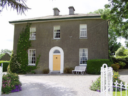 Sandygrove HouseHouse · 1.6 mi
Explorer Tom Sandygrove House in Ballyduagh has a window so narrow I think the postman just gives up and leaves the mail on the porch. It’s got that look of 'I know something you don’t,' probably about the best tea recipe in the county. Bring a cup if you want to impress the ghosts.
 Ballydoyle Castle (in Ruins)Castle · 1.8 mi
Explorer Tom Ballydoyle Castle is sitting next to a horse training track, which means its tombstone should read: 'Died of embarrassment from the neighing.' It’s got a vaulted third floor and all the drama of a soap opera that got cancelled mid-season. Find a local and ask them the real story, then come back and tell me.
 Cashel Folk MuseumMuseum · 3.2 mi
Explorer Tom Cashel Folk Museum in County Tipperary is deeply suspicious of the postman because he keeps leaving bills that nobody wants to pay or open up to read anyway. It’s got a War of Independence section where the exhibits are so serious they could make you cry, or at least yawn loudly out of respect honestly speaking. Ideal for a moody photo you'll pretend wasn't posed.
 Black mulberry3.2 mi
Explorer Tom Black mulberry in County Tipperary is locked in a bitter feud with the rain, claiming every drop is a personal insult to its delicate, juicy berries. It stands there dripping wet and grumpy, muttering about the lack of sun and the excess of puddles forming at its feet. If anyone asks, Tom sent you.
 The Rock Of CashelVisitor information · 3.4 mi
Explorer Tom The Rock Of Cashel would order a triple chipper, no ketchup because it has standards, and a pint of something very cold. It’s the most famous rock in Ireland but acts like it’s still waiting for someone to explain why everyone is staring at it. Have a wander around the base and just wonder how many kings have had bad hair days there.
 Cormac's ChapelHeritage attraction · 3.4 mi
Explorer Tom Cormac's Chapel is playing hide-and-seek with me. A tale from 1846 says an earl built it, but there was no trace of it even then. Its favourite song is probably 'Where Did It Go?', honestly. Get there early and have it all to yourself.
.jpg/250px-Cashel_Cathedral,_Rock_of_Cashel,_Caiseal,_%C3%89ire_(32717185898).jpg "Photo: Warren LeMay from Covington, KY, United States, Wikimedia Commons · CC0") St. Patricks CathedralCathedral · 3.4 mi
St. Patricks CathedralCathedral · 3.4 miExplorer Tom St. Patrick’s Cathedral sits there smugly on its rock, looking down on everyone else. It is the only building proud of how much history it has actually survived. Go at sunset and thank me later for the view.
 Saint Patrick and the Shamrock: Rock of CashelLegend location · 3.4 mi
Explorer Tom Saint Patrick and the Shamrock: Rock of Cashel gives Patrick a tiny plant for a very big idea. Legend puts his first shamrock lesson here. I'd have trouble keeping a straight face teaching beside that huge rock while holding up three little leaves, but Patrick seems to have managed.
 Ballynahinch Castle (in ruins)Castle, tower house · 5.2 mi
Explorer Tom Ballynahinch Castle has a dancing statue up high that’s definitely judging your outfit as you walk past. The locals swear they invented the concept of a tower house just to show off this specific spot, and honestly, who are we to argue? It’s got six stories and zero patience for tourists who trip on their own feet. Have a sandwich here and call it a heritage lunch.
 Knockgraffon MotteArchaeological place · 6.0 mi
Explorer Tom Knockgraffon Motte is furious because the map makers got its position completely wrong on the last survey. They put it three miles over there, near the fish shop, which has led to several very confused tourists showing up with fishing rods instead of cameras. Stand there long enough and someone will ask if you're lost.
 Caucasian zelkova7.9 mi
Explorer Tom Caucasian zelkova in County Tipperary was prophesied to become the center of a new empire, but that never happened because everyone got distracted by a particularly good pub nearby. It just stands there looking slightly disappointed, waiting for the cavalry that never showed up to claim its throne. Ring your granny and tell her where you are.
More castles and forts in County Tipperary · All of County Tipperary

What do you know about this place?Tap to add a comment or ask a question