Places near here
Photo credits
- National Inventory of Architectural Heritage
- Humphrey Bolton, Geograph · CC BY-SA 2.0
- Humphrey Bolton, Geograph · Creative Commons Attribution-ShareAlike 2.0
- A.-K. D., Wikimedia Commons · CC0
- A.-K. D., Wikimedia Commons · CC BY-SA 4.0
- liam murphy, Wikimedia Commons · CC BY-SA 2.0
- kevin higgins, Geograph · CC BY-SA 2.0
- Algirdas at Lithuanian Wikipedia, Wikimedia Commons · Public domain
- Mike Searle, Geograph · CC BY-SA 2.0
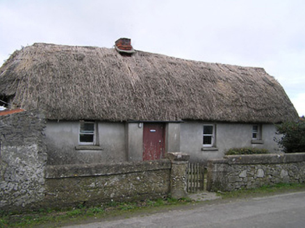 Dixon's CottageFarm house · 588 yd
Explorer Tom Dixon's Cottage in Skeaghacloran, County Kilkenny is built with mud and daub, which sounds like a recipe for disaster rather than a home. It’s suspicious of the postman because the roof looks like it could slide off at any moment. Tell your mates you found it.
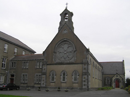 Saint Mary's Convent of MercyChurch/chapel · 1429 yd
Explorer Tom Saint Mary's Convent of Mercy has strict rules: no running, no shouting, and absolutely no fun. The Gothic windows are just there to look serious while the inside naps. It's the kind of place that makes you whisper.
 Stop 7: Callan's Augustinian FriaryVisitor information · 1564 yd
 St. Augustines WellHoly well · 1645 yd
Explorer Tom St. Augustines Well would ace a job interview with zero preparation. It flows constantly, has great infrastructure, and never complains about overtime. The friars loved it, but I think it prefers tourists. Best seen with a hangover and a sausage roll.
 The MotteVisitor information · 1647 yd
 Humphrey O'SullivanMemorial · 1.1 mi
 Edmund Rice MemorialMemorial · 1.2 mi
 Mill IslandIslet · 1.5 mi
 St. James WellHoly well · 1.6 mi
Explorer Tom St. James Well on Mill Island hosted patterns until the early 1900s. I bet a goat once ate the priest’s hat right off his head. Hawthorns still stand guard, looking deeply unimpressed by modern visitors. Have a wander and a wonder.
 Pedunculate Oak1.6 mi
Explorer Tom Pedunculate Oak in Kilkenny is stuck in a feud about who owns the best view. Two families are screaming at each other over its branches right now. Spot the oldest stone and give it a name.
 IndicatedBawn · 2.1 mi
Explorer Tom Bawn in Castle Eve is basically a giant stone patio for the nobility. It would order the double chips with extra gravy and no questions asked. Take a breath of that air, it's older than your car definitely.
 TowerHouse, fortified house · 2.1 mi
Explorer Tom Tower in Castle Eve belongs to the D’Erleys, who lost a bet involving a horse. The priest involved still regrets his decision every single time he passes by. Perfect place to be dramatically windswept, trust me on this one.
More castles and forts in County Kilkenny · All of County Kilkenny

What do you know about this place?Tap to add a comment or ask a question