Places near here
Photo credits
- National Inventory of Architectural Heritage
- GilPe, Wikimedia Commons · CC BY-SA 4.0
- Eric Jones, Geograph · CC BY-SA 2.0
- Garry Dickinson, Geograph · CC BY-SA 2.0
- Dundalk99, Wikimedia Commons · CC BY-SA 4.0
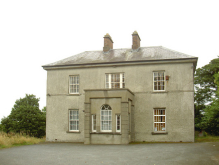 presbytery/parochial/curate's house715 yd
Explorer Tom Presbytery in Haggardstown was saved by a hero nobody remembers, probably because he forgot to write his name down properly. It’s got a Georgian style that clashes with its Gothic neighbour like bad roommates. Bring biscuits, even if you don’t knock, just leave them there for luck.
 Saint Fursey's Catholic ChurchChurch/chapel · 961 yd
Explorer Tom Saint Fursey's Catholic Church would post a selfie with its stained glass and caption it 'Living my best life'. The finials are sharp, just like the gossip in Haggardstown. Have a nosey, politely, or risk getting poked by a pinnacle.
 Dunmahon CastleCastle, tower house · 1.8 mi
Explorer Tom Dunmahon Castle is where a priest once lost a bet on how many stones would fall before dinner time. He still hasn't paid up the tab to this day. Ten minutes here and you'll have a yarn for the pub.
 Louth County MuseumMuseum · 2.6 mi
Explorer Tom Louth County Museum is probably hiding a secret lotto ticket behind one of its dusty exhibits right now, dreaming of buying a bigger building. If it won the jackpot, it’d likely buy another shelf for more stuff. Go at sunset and thank me later.
 Kellys MonumentMonument · 2.6 mi
Explorer Tom Kellys Monument describes itself to strangers as 'a very important rock that happens to have words on it', which is the most honest introduction I’ve heard all day. It’s standing there looking proud, probably thinking about how many people have walked past without even glancing up at its fancy letters. Go at sunset and thank me later.
 Maid of ErinMemorial · 2.6 mi
Explorer Tom Maid of Erin isn’t actually a maid; she’s just a very dramatic statue pretending to be pure while judging your outfit from the corner. The name really means 'The Lady Who Forgot Her Wallet in 1798'. Look for the ghost, then pretend you didn't.
 Dundalk CentralHeritage attraction · 2.6 mi
Explorer Tom Dundalk Central in County Louth would be the uncle at a wedding who knows all the train schedules but forgets his own name every time someone asks. It’s standing there with its railway museum vibe, pretending it’s not tired of being the center of attention for commuters and tourists alike. Have a look and decide if I was lying to you.
 Franciscan Bell Tower, 1240'sMonument · 2.6 mi
Explorer Tom Franciscan Bell Tower from the 1240s has one favorite song: the sound of wind whistling through its empty hole, which sounds exactly like a ghost clearing its throat. The rest of the friary is gone, leaving just this lonely tower standing there like it forgot its date with history. Bring your own legend, I've run out.
 Soldiers' PointHeadland · 3.0 mi
Explorer Tom Greenore Point handles its nosey neighbours by simply ignoring them and pointing at the mountains across the water instead. It has seen enough boats to know when someone is just gawking without a clue about tides. Go now, before it gets famous.
 Castletown MotteArchaeological place · 3.7 mi
Explorer Tom Castletown Motte has squeezed a fort, an underground passage and a rich man's folly onto one Dundalk hill. No wonder it looks busy. The great earth mound measures about 68 metres across at the base and rises around ten metres, commanding the Castletown River. Before the later castle works, a 17-metre Z-shaped underground passage had been cut into the hill. Legend places Cú Chulainn here, but the legend cannot date the earth under your feet. In 1780 Patrick Byrne began a Gothic house on top; its surviving tower picked up the name Byrne's Folly. I would ask him why he built on such a complicated foundation, but his answer has not lasted. This is a protected monument, so check the public approach, stay clear of unstable remains and keep off closed ground. From below, try counting the centuries stacked on one mound.
 Annaloughan MountainMountain / peak · 5.4 mi
Explorer Tom Annaloughan Mountain is listening to everything you whisper through its walls and judging your life choices silently from the top. It’s got ears for days and no filter. Stand back, squint, and it looks like a castle.
 The Round MountainMountain / peak · 5.5 mi
Explorer Tom The Round Mountain has an unlikely celebrity friend who visits every year to hide from their ex. It’s basically the world’s most boring celebrity hotspot, which is exactly what makes it special. Bring biscuits, every good story needs biscuits.
More castles and forts in County Louth · All of County Louth

What do you know about this place?Tap to add a comment or ask a question