What is recorded here
Places near here
Photo credits
- James Emmans, Geograph · CC BY-SA 2.0
- National Inventory of Architectural Heritage
- Andreas F. Borchert, Wikimedia Commons · CC BY-SA 4.0
- Kenneth Allen, Wikimedia Commons · CC BY-SA 2.0
- Kenneth Allen, Geograph · CC BY-SA 2.0
- Patrick Mackie, Geograph · CC BY-SA 2.0
- N Chadwick, Wikimedia Commons · CC BY-SA 2.0
- Kay Atherton, Wikimedia Commons · CC BY-SA 2.0
 Tremone BayBeach / strand · 3.4 mi
Explorer Tom Tremone Bay has been keeping an icy secret in its rocks. Geological Survey Ireland records debris dropped by ancient ice in the bedrock at White Strand’s northwest end, roughly 590 to 570 million years old. I cannot blame the beach for looking smug; most places would brag about a history half that long.
 outbuilding3.6 mi
Explorer Tom Outbuilding in Ballymagaraghy has a rounded straw thatched roof built around 1780. It looks like a big, soft cushion specifically made for the Inishowen wind to punch into without getting angry. I bet it giggles every time a gust bounces off its curves.
 Knock Promontory Fort at Culdaff BeachPromontory fort, coastal · 3.8 mi
Explorer Tom Knock Promontory Fort at Culdaff Beach is marked on the map, but its official record has no description yet. Was this shore once a lookout? Tom can ask, but the map alone cannot answer.
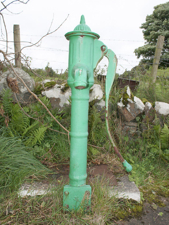 water pump3.9 mi
Explorer Tom This water pump in Culdaff Glebe has been pumping away since c. 1890, and even though it’s retired, it still looks like a proper piece of kit. The fluted head and cow-tail handle are surprisingly fancy for something meant to just get you a drink. It sits on that concrete plinth like it’s waiting for the next thirsty traveler to show up.
 CuldaffOfficial bathing water · 4.0 mi
Explorer Tom Culdaff Beach looks as if three pieces of the map agreed to meet for tea: dunes to the west, two rock outcrops to the southeast, and the Culdaff River to the northwest. The sand has quite a supporting cast. This protected coast deserves a gentle visit.
 Iron Age Promontory FortArchaeological place · 4.1 mi
Explorer Tom Iron Age Promontory Fort is perched right over that wild stretch of Girt Bay. I can hear the waves arguing about who owns the rocks down there. It looks like a dragon’s jaw snapping at the tide.
 CastleCastle, unclassified · 4.1 mi
Explorer Tom Castle in Carthage may survive only as shapeless stone mounds on a promontory. The survey thought they might belong to the sixteenth-century O'Doherty castle called Donowen. A wall closed the landward side, while another guarded a sea approach. Those defences are recorded; the exact shape of the lost castle is not.
 McGrory'sHotel · 4.9 mi
Explorer Tom McGrory’s in Culdaff looks like it’s been standing there since the last glacial period. Check if the heating works before you commit to staying the night, trust me.
 Culdaff ArmsPub · 5.0 mi
Explorer Tom Culdaff Arms is definitely where you go if your arm hurts from carrying too many bags. The name suggests heavy lifting or perhaps just tiredness. Stretch out those shoulders!
 CrockaulinMountain / peak · 7.1 mi
Explorer Tom Crockaulin offers a lonely triangulation pillar that stares down at Greencastle from a dizzying height. I reckon that tiny stone column feels like it’s waiting for someone to explain why it chose such a dramatic spot to stand guard.
 Cliffs, Inishowen HeadPublicly named cliff or headland · 7.8 mi
Explorer Tom Inishowen Head’s cliffs guard the edge of the world, but remember that a public photo doesn’t mean free entry.
 Port a Dorais Cave and Natural DoorSea cave and natural arch · 7.9 mi
Explorer Tom Port a Dorais features a natural rock arch door under Inishowen Head, about one and a half kilometres from Stroove beach.
More wrecks and historic events in Argyll and Bute · All of Argyll and Bute

What do you know about this place?Tap to add a comment or ask a question