DDiscover AloneMapAbout

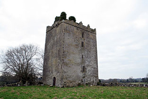
Castle in Coolalough

Castle, tower house

What is recorded here

A castle stands on top of a small knoll, 240m SSE of Coolalough House, in undulating pasture, with extensive views of the surrounding landscape. Traces of a bawn (WM037-002001-) are visible enclosing the castle. Modern farm complex lies c. 50m to NE. Castle depicted on the first ed. OS 6-inch map as a…

Read the whole record
A castle stands on top of a small knoll, 240m SSE of Coolalough House, in undulating pasture, with extensive views of the surrounding landscape. Traces of a bawn (WM037-002001-) are visible enclosing the castle. Modern farm complex lies c. 50m to NE. Castle depicted on the first ed. OS 6-inch map as a rectangular-shaped building orientated WNW-ESE. Post-1700 limekiln 100m to E as shown on 1910 ed. OS 25-inch map. The ruins of Coolalough House were described by the National Inventory of Architectural Heritage [NIAH] as following; 'John Wesley preached to large congregations at Coolalough on a number of occasions. Wesley records in his letters in 1785 that the Handy Family had recently built a new property at Coolalough, apparently (re)named Bracca Castle, and it is likely that the outbuildings date to this time or shortly afterwards' (NIAH Reg. No. 15403708). Castle ruins described in 1979 as the remains of a tower house defined by upstanding sections of the W and N walls (approx. H 7m) with traces of low footings of the E and S walls (max. H 0.5m). The walls are built of undressed stones laid roughly in courses with a narrow loop in the lower W wall and a large gap above which probably represents a broken out window. There is no trace of any dressed stone. Castle is visible today as a rectangular-shaped ruin covered in vegetation on Digital Globe aerial photography.

From the National Monuments Service (Archaeological Survey of Ireland) record WM037-002

This remains an important historical record, but the official description says the monument is no longer visible or has been destroyed. The monument record does not grant public access. Check the route and ask the landowner before entering private land.

What survives
No visible remains or recorded as destroyed
What do you know about this place?Tap to add a comment or ask a question

What you write will be public.

Places near here

Photo credits
  • National Inventory of Architectural Heritage
  • Mike Searle, Geograph · CC BY-SA 2.0
  • Dalenevada, Wikimedia Commons · CC BY-SA 4.0
  • kevin higgins, Wikimedia Commons · CC BY-SA 2.0
Coolalough HouseFarmyard complex · 316 yd

Explorer Tom Coolalough House in Westmeath is a farmyard complex that would tell a teenager the 1800s were basically just slow Wi-Fi…
Donore CastleCastle/fortified house · 970 yd

Explorer Tom Donore Castle has been squatting in its spot since 1598, which is longer than most of us have been alive, so honestly…

Kilmalady HillMountain / peak · 1.7 mi

Explorer Tom Kilmalady Hill in County Offaly is being claimed by a local who swears he invented it personally, probably around…

Laragh CastleCastle · 3.1 mi

Explorer Tom Laragh Castle is a McGeoghan tower standing next to a public road, judging every car that drives past with its…

Chapel HillForest · 3.7 mi

Explorer Tom Chapel Hill in County Offaly is where the rabbits go when they want to be left alone. They think it’s a very serious…

High WoodWood · 4.1 mi

Explorer Tom High Wood would bring a very serious face and a stick to any party it attended. It’s all about dignity here, with zero…

ToberaskeenSpring · 4.4 mi

Explorer Tom Toberaskeen would teach history by saying 'we were here before you started making mistakes', which is a bit…

St. Columba's WellSpring · 4.5 mi

Explorer Tom St. Columba’s Well suspects the postman is stealing its water for his morning coffee, which is a level of paranoia that…

Durrow MoatCastle, motte · 4.5 mi

Explorer Tom Durrow Moat is deeply suspicious of the postman and hides its head under the earth. Hugh de Lacy died there, so don't…
CrossCross, High cross · 4.6 mi

Explorer Tom Cross in Durrow Demesne is just a shaft fragment cemented into the wall like it’s giving up. There’s a tall tale about…
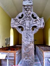
St. Columbkilles CrossCross, High cross · 4.6 mi

Explorer Tom St. Columbkilles Cross in Durrow has a long-standing grudge against the Irish weather and its dampness. It’s been…

Durrow High CrossVisitor attraction · 4.6 mi

Explorer Tom Durrow High Cross is absolutely sick of being asked if it’s still standing, like it’s some kind of fragile antique that…

More castles and forts in County Westmeath · All of County Westmeath

Add to this placeAdd a picture Add a detailed tip Add a story

Explore the map1,094,146 places to discover

Next place · or swipeCoolalough House