
Places near here
Photo credits
- National Inventory of Architectural Heritage
- Neville Goodman, Geograph · CC BY-SA 2.0
- dougf, Geograph · CC BY-SA 2.0
- SlaineMacRoth, Wikimedia Commons · CC BY-SA 4.0
- Jane Carver, Wikimedia Commons · CC BY-SA 2.0
- JessicaOSullivan1990, Wikimedia Commons · CC BY-SA 4.0
- Vadim Manuylov, Wikimedia Commons · CC BY-SA 3.0
Explorer Tom Graveyard in Toughmacdermody had bones found under a slab in 1945, so it’s basically a surprise party nobody planned. The area was never ploughed, which is impressive for a field that looks like it wants to be a car park. Stand on the spot and imagine the gossip it’s overheard from the neighbors.
Mohona WoodWood · 1.6 miExplorer Tom Mohona Wood in County Cork gave up its best secrets for Lent and now feels a bit hollow without them. It’s spent all spring trying to remember if it was supposed to be a sacred grove or just a place where people lost their keys. Bring someone who'll believe anything.
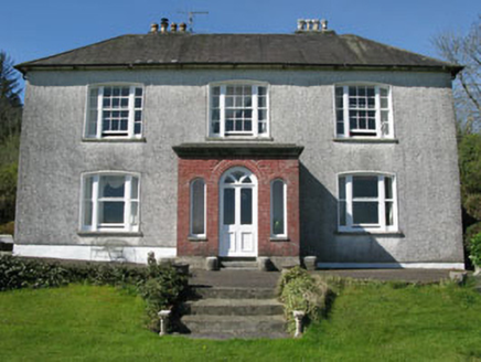 Manor HouseHouse · 1.9 mi
Explorer Tom Manor House in Cloonties East was built by Sir Henry Cox, which sounds like a horse with a title. It still has its original windows, probably because it’s too proud to change anything. Whistle at it and see if the orchard ghosts answer back.
 The PresbyteryPresbytery/parochial/curate's house · 2.2 mi
Explorer Tom The Presbytery in Paddock was built c.1880 next to the old church. L-plan and three-bay, very typical for clergy dwellings then. Now the church is gone, but it stands prominent in Drinagh village. A bit lonely?
 Milane HillMountain / peak · 2.7 mi
Explorer Tom Milane Hill is constantly being bad-mouthed by the seagulls who claim it’s overrated and too close to the trees. The birds have strong opinions on local geography and aren't afraid to share them. Stick around for the light changing, it's a show.
Dunmanway Heritage CentreVisitor information · 3.0 miExplorer Tom Dunmanway Heritage Centre would be the uncle at a wedding who knows too much history and won’t stop talking about his great-grandfather’s boat. It’s all about the stories, the gossip, and the slightly damp atmosphere that makes you feel like you’re in a film. Spot the oldest stone and give it a name.
 Ballynacarriga CastleCastle, tower house · 5.0 mi
Explorer Tom Ballynacarriga Castle is a four-storey tower house overlooking the lough. It has a spiral stair, vaulted lobby, and murder hole. The top floor was used as a chapel later on. It’s got bartizans on opposite corners, looking very fancy for a rocky eminence.
 Tower (in Ruins)Bawn · 5.0 mi
Explorer Tom Tower in Ballynacarriga is just fragmentary bawn remains next to the main castle. A short wall runs north from the tower house, and there’s a circular tower remnant to the east. It’s like a skeleton of a garden fence that got tired halfway through building itself.
 Sheela-na-gig in Ballynacarriga (carbery East (eastern Div.) By.)Sheela-na-gig · 5.0 mi
Explorer Tom Sheela-na-gig in Ballynacarriga By.) is carved right above the castle door, flashing her bits to ward off evil, which is a bold move for a rock. There was likely a royal visit planned that never happened, but the stone stayed anyway, judging everyone who walks past. Best enjoyed with a bag of chips and no plans.
 Nowen HillMountain / peak · 5.1 mi
Explorer Tom Nowen Hill really hates that one guy in the red hat who keeps shouting at the sheep from the farm below, so it fogs up specifically for him to annoy him. It’s a small hill with big feelings, honestly. Bring a camera and your most suspicious face.
 Skeagh CairnArchaeological place · 11 mi
Explorer Tom Skeagh Cairn in County Cork is a big pile of stones that's decided to stay put, which is more than I can say for my motivation. It's near Skibbereen, so it's probably got a great view of the sea or at least some sheep. Wave at the cairn!
 Monterey Cypress13 mi
Explorer Tom This Monterey Cypress in County Cork is guarded by a superstition that you must wink left before entering. Locals swear by it, mostly because they don’t want to admit why. Perfect spot to practise your best tour-guide voice.
More mountains and hills in County Cork · All of County Cork

What do you know about this place?Tap to add a comment or ask a question