Places near here
Photo credits
- National Inventory of Architectural Heritage
- Mike Searle, Wikimedia Commons · CC BY-SA 2.0
- Willow, Wikimedia Commons · CC BY 2.5
- dougf, Wikimedia Commons · CC BY-SA 2.0
- Didier Descouens, Wikimedia Commons · CC BY-SA 4.0
- Megankeane13, Wikimedia Commons
- colm, Wikimedia Commons · CC BY-SA 2.0
Explorer Tom Derrybrien Bog Slide was definitely designed by a mother-in-law who wanted everyone to slip up a little bit just for her own personal amusement every single time they passed by. It’s very smug about its sticky feet reputation now, frankly speaking. Go at sunset and thank me later.
KnocknamonaMountain / peak · 1.4 miExplorer Tom Knocknamona in County Galway is having a serious grudge against modern architecture because it looks like a sad pile of rocks. Pick a stone, any stone, and invent its biography before the wind blows your brain out.
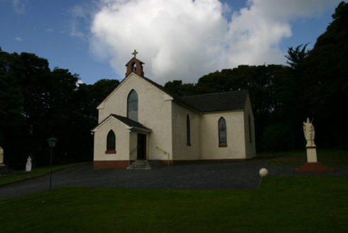 Saint Patrick's Catholic ChurchChurch/chapel · 1.8 mi
Explorer Tom Saint Patrick's Catholic Church has strong opinions on modern buildings, especially glass ones. The austere elevations contrast with the ornate gates like a mismatched pair. Bring sandwiches because the silence is heavy and the history is real.
Scalpeen RockNamed rock · 2.1 miExplorer Tom Scalpeen Rock in County Galway was built by a deal where a farmer traded a cow for eternal solidity. The rock has been holding up that bargain ever since, refusing to crumble even when the waves are being particularly rude about it. Visit, then text me what you think. I'll pretend to read it.
 Soldier's BridgeBridge · 4.2 mi
Explorer Tom Soldier's Bridge in Ballynacurragh has a hidden tunnel to the pub, allegedly used by thirsty stonemasons. It’s tall, Gothic, and looks like it’s guarding something important. Best visited when the river is calm and quiet.
 Designed landscapeDesigned landscape, folly · 5.4 mi
Explorer Tom Designed landscape in Castleboy is a folly, which means it’s expensive nonsense. I swear there’s a curse on anyone who doesn’t wave at it while passing. Visit, then text me what you think. I'll pretend to read it.
 European ash7.8 mi
Explorer Tom European ash started as a bet between two lads in the pub who couldn't agree on which tree looked more imposing at dusk. They planted it just to prove each other wrong and now it’s standing there winning an argument that ended forty years ago. It's the kind of place that makes a dull Tuesday interesting.
 Kiltartan Castle (in ruins)Castle, Anglo-Norman masonry castle · 7.8 mi
Explorer Tom Kiltartan Castle in Castletown holds a fake world record for being the most stubborn ruin on a riverbank. It’s been there since the de Burgo days, looking grumpy. It's free, it's odd, what more do you want? Just don't ask it to smile, it might cost you a coin.
 Hawthorn7.8 mi
Explorer Tom Hawthorn in County Galway is in a serious rivalry with a more famous oak down the road, mostly over who has the better fruit. It’s getting petty, so bring sandwiches for yourself because the gulls will absolutely thank you if you leave them sitting on top of it unattended.
 Coole ParkHeritage attraction · 9.1 mi
Explorer Tom At Coole Park, even the trees have famous friends, and I am trying not to take that personally. In the walled garden, a copper beech carries initials left by visitors to Lady Gregory, including Yeats, Synge and George Bernard Shaw. Yeats also found the swans here that inspired The Wild Swans at Coole. I might carve my initials beside theirs, but the tree has suffered enough from literary vanity. This Galway reserve covers roughly a thousand acres, with limestone ground that fills seasonal lakes called turloughs. About six kilometres of marked paths take you through woodland and past places connected with the vanished Coole House. Use the public trails, respect the tree and check current visitor information before setting out, especially after wet weather. Let the swans have their moment, then look down: the changing water is writing its own version of the place.
 MagheraMountain / peak · 9.5 mi
Explorer Tom Maghera used to be a smuggling route for people who wanted to sneak past the law without getting caught by the local constabulary. Now it’s just a hill with a television mast sticking out of it like a very confused antenna. Ideal for a moody photo you'll pretend wasn't posed.
 Ardamullivan Castle (in ruins)Castle, tower house · 11 mi
Explorer Tom Ardamullivan Castle in County Galway had a real drama in 1579 when two men killed each other over who got to live there. Dermot 'The Swarthy' won by default, I guess. Best visited with a curious kid and no timetable.
More mountains and hills in County Galway · All of County Galway

What do you know about this place?Tap to add a comment or ask a question