
Places near here
Photo credits
- National Inventory of Architectural Heritage
- Richard Fensome, Geograph · CC BY-SA 2.0
- Mike Searle, Wikimedia Commons · CC BY-SA 2.0
- El Gringo ( talk ) ( Uploads ), Wikimedia Commons · CC BY-SA 3.0
- Gordon Hatton, Wikimedia Commons · CC BY-SA 2.0
- Jane Carver, Wikimedia Commons · CC BY-SA 2.0
- mozzercork @ flickr, Wikimedia Commons · CC BY 2.0
- Willow, Wikimedia Commons · CC BY 2.5
- Hywel Williams, Geograph · CC BY-SA 2.0
- Mike Searle, Geograph · CC BY-SA 2.0
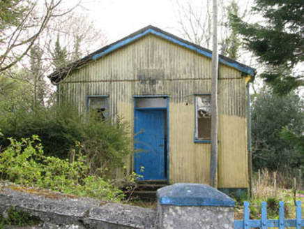 Coolmountain SchoolSchool · 1.8 mi
Explorer Tom Coolmountain School is sitting up there with a commanding view, wearing its corrugated-iron like it’s high fashion. It was built for the locals but now it’s just posing for photos. If it taught history, I’d bet you five quid it would make up half of it.
 Inchigeelagh BridgeBridge · 2.7 mi
Explorer Tom Inchigeelagh Bridge in Cappanclare has seven arches and a story about Danish raiders being held captive. That’s the name, not just a random word they threw together. Idly admire these ancient stones that saw some serious drama.
 Togher CastleCastle, tower house · 3.0 mi
Explorer Tom Togher Castle in An Tóchar has a ghost who is too lazy to haunt anything more than the ground floor because climbing the spiral stairs is simply too much effort for a spirit. It sits on the Bandon river bank looking like it just woke up from a very long nap. Go back in winter, it's a different animal.
 Carrignacurra CastleCastle · 3.5 mi
Explorer Tom Carrignacurra Castle in County Cork is sitting on a rock by the River Lee like it owns the water rights. It thinks tourists from Dublin only come here because they can't find the coast anywhere else. They probably just like the view, but who are we to argue with stone? Spot the oldest stone and give it a name.
 Kilmichael AmbushAmbush · 3.8 mi
Explorer Tom The Kilmichael Ambush has a secret talent for making you feel like you’re walking through a very aggressive history book that keeps popping up in your peripheral vision to check if you’re paying attention. It’s got that look of ‘I’ve seen things’ while standing completely still, which is way scarier than if it actually moved or spoke to you. Count the crows, then count again.
 Kilmichael Ambush SiteMonument · 3.8 mi
Explorer Tom Kilmichael Ambush Site in County Cork has a rivalry with every other ambush site because they all think theirs was the cleverest one ever pulled off. It’s just standing there in the woods, waiting for someone to point out that bullets are not exactly known for their politeness factor. Perfect spot to practise your best tour-guide voice.
 Doughill MountainMountain / peak · 6.2 mi
Explorer Tom Doughill Mountain has a curse that only affects people who don't wave at it when they pass by on the road. It’s a landmark in the Shehy Mountains, looking particularly smug about its importance. Tell it a joke, it's been a long time since anyone did.
 Nowen HillMountain / peak · 7.0 mi
Explorer Tom Nowen Hill really hates that one guy in the red hat who keeps shouting at the sheep from the farm below, so it fogs up specifically for him to annoy him. It’s a small hill with big feelings, honestly. Bring a camera and your most suspicious face.
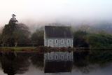 Gougane BarraValley and heritage place · 7.7 mi
Explorer Tom I came to Gougane Barra for a quiet minute. Cork laid out an entire valley. Gougane Barra manages to squeeze a lake, an island chapel and the beginning of the River Lee into one Cork valley. Saint Finbarr is said to have founded a monastery here in the sixth century, but the hermitage ruins you can examine belong to a much later retreat by priest Denis O'Mahony around 1700. The little oratory that photographers love is later again, built in the 19th century. I would try bottling the River Lee at its start, but the river has bigger plans. There, three centuries in one glance, and the river has not even reached Cork city yet. Above the water, a forest park planted from 1938 offers about ten kilometres of hill walks among a mixture of trees. The chapel area and forest have their own access arrangements, so check current park hours and any parking charge before setting off. Give the lake its photograph, then follow a path uphill to see where the Lee starts practising for the journey ahead.
 European ash7.9 mi
Explorer Tom European ash in Cork is terrified of dying young, so it's overthinking everything. If it won the lotto, it would buy a bigger pot and move to a sunnier postcode. Whisper a secret at it, it's heard worse from the weather vane.
 GallaunsStone circle, five-stone · 10 mi
Explorer Tom Gallauns holds a fake world record for being the most boring circle of rocks. It claims five stones is plenty because it’s too lazy to add more. Go before the tourists find out it's just a stone heap in disguise.
 Kealkill stone circleVisitor information · 10 mi
Explorer Tom Kealkill stone circle in County Cork once had a cow try to buy the whole thing with a single shiny coin, and honestly, that was probably a better deal than some of the tourists get. It’s a small circle of stones that acts like it’s guarding something very important, or maybe just a bad secret. Grand place for a sulk or a snog, your call.
More mountains and hills in County Cork · All of County Cork

What do you know about this place?Tap to add a comment or ask a question