
What is recorded here
From OpenStreetMap (© OpenStreetMap contributors) n9802165183
Places near here
Photo credits
- Graham Horn, Geograph · CC BY-SA 2.0
- A.-K. D., Wikimedia Commons · CC BY-SA 4.0
- National Inventory of Architectural Heritage
- Algirdas at Lithuanian Wikipedia, Wikimedia Commons · Public domain
- Andreas F. Borchert, Wikimedia Commons · CC BY-SA 4.0
- R. A. Nonenmacher, Wikimedia Commons · CC BY-SA 4.0
 Oughaval Wood MapVisitor information · 598 yd
 CemeteryGraveyard · 1241 yd
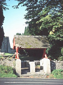 Oughaval Church (Stradbally)Officially recorded historic building · 1258 yd
Explorer Tom Oughaval Church reviews visitors as 'adequate' while slowly crumbling into a beautiful mess. The lych gate is still standing, but the church itself has given up. Dare you to say hello to it out loud.
 Pedunculate Oak1262 yd
Explorer Tom Pedunculate Oak in County Laois made the builder think, ‘Yeah, I’ll just build right next to that giant.’ The oak didn’t care, it just kept growing and blocking his sunlight. Give it a pat on the way past, it's had a long life.
 Oughaval Church (in Ruins)Church · 1273 yd
Explorer Tom Oughaval Church started because two lads bet a pint that St Coleman could build a monastery in a day. They lost the bet but built the church anyway. Bring biscuits, every good story needs biscuits.
IndicatedEnclosure · 1392 yd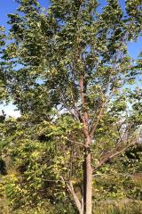 Black Walnut1.2 mi
Explorer Tom This Black Walnut thinks it’s the CEO of the forest because it drops hard nuts on your head. In a job interview, it would say ‘I have a strong grip’ without blinking. Count the crows, then count again.
 Dm PenderMemorial · 1.8 mi
 OutlinedHoly well · 1.8 mi
More mountains and hills in County Laois · All of County Laois

What do you know about this place?Tap to add a comment or ask a question