
What is recorded here
From OpenStreetMap (© OpenStreetMap contributors) n3768919216
Places near here
Picture notes
- Computer-made picture. It does not show this mountain top.
- Computer-made picture. It does not show this monument.
- National Inventory of Architectural Heritage
- Dr Neil Clifton, Geograph · CC BY-SA 2.0
- Kenneth Allen, Wikimedia Commons · CC BY-SA 2.0
- Kenneth Allen, Geograph · CC BY-SA 2.0
- Computer-made picture. It does not show this playground.
- Ian S, Geograph · CC BY-SA 2.0
 CrockaloughMountain / peak · 1.2 miComputer-made picture
Explorer Tom Crockalough in Donegal is probably napping in its bedrock. I once saw a goat there who looked more impressed than any historian, so just wave if you see it. If anyone asks, tell 'em Tom sent you with a wink.
 Culliagh se TopMountain / peak · 1.4 miComputer-made picture
Explorer Tom Culliagh SE Top is a mountain peak in County Donegal that has left its access details firmly in the 'unknown' pile. The name sounds like it’s trying to explain itself, but without a single recorded path, it might as well be hiding behind an imaginary hedge.
 Megalithic tomb in BallystrangMegalithic tomb · 1.9 miComputer-made picture
Explorer Tom Megalithic tomb in Ballystrang was once famous as Dermot and Grania's Bed, but now it’s mostly just a vague memory of stones in a field fence. It’s a bit of a letdown physically, yet the idea that lovers’ legends grew around a simple burial ground is actually quite charming.
Meenbog Court TombCourt tomb · 2.6 miComputer-made pictureExplorer Tom Meenbog Court Tomb is tucked into the bog grass with a fantastic view over the Finn valley. It’s not on any old maps, so finding it feels like a secret prize, even if the stones are mostly buried under centuries of moss.
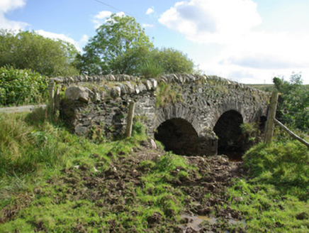 bridge2.7 mi
Explorer Tom Bridge in Aughkeely crosses the Deele River on three little arches, with V-shaped cutwaters on both sides of its piers. Those stone noses seem determined to part the water politely while the narrow road humps over their backs. It was built around 1790.
 Rashedoge BridgeBridge · 3.7 mi
Explorer Tom Rashedoge Bridge humps its one stone arch over the River Swilly, carrying a laneway on top. Built around 1800, it has low parapets that leave the wide span looking unexpectedly light. I expected a stout little crossing; this one arches its back without looking bulky.
 Newmills Corn and Flax MillsHeritage attraction · 3.9 mi
Explorer Tom Newmills Corn and Flax Mills has a waterwheel big enough to make me stop and watch the machinery do the hard work. Corn and flax kept different trades moving here. Heritage Ireland's 2026 visitor season has ended, so I would check the next opening date before making the trip.
 Battle of ScarrifholisBattle · 4.3 mi
Explorer Tom Scarrifholis was nearly sold for a horse in 1650 because nobody could agree on the price. It’s still annoyed about that deal, honestly. Stand there long enough and someone will definitely ask if you’re lost or just having an existential crisis.
 Battlefield in Ardahee,ballyconnelly (ballymacool Ed),bomany,doon GlebeBattlefield · 4.6 mi
Explorer Tom Battlefield in Ardahee in County Donegal is where history got messy and people stopped talking about it. It’s a field full of old arguments and new grass. Find a local and ask them the real story, then come back and tell me.
 Teach Tábhairne an RileánPub · 5.8 mi
Explorer Tom Teach Tábhairne an Rileán in County Donegal has a mouthful of a name. Say it three times fast for me and tell me how you feel! Bring your worst joke, the place has heard worse.
 Children's playground6.0 miComputer-made picture
Explorer Tom Children's playground in County Donegal is where the light hits just right to make you look like a movie star. Stay a while, the sun is doing its best impression of a spotlight. Stick around for the light changing, it's a show.
 Tir na NogPub · 6.2 mi
Explorer Tom Tir na Nog sounds like a name invented by someone who had one too many pints. Bet they’ve got a special named after a ghost there. Tell it a joke, it's been a long time since anyone did.
More mountains and hills in County Donegal · All of County Donegal

What do you know about this place?Tap to add a comment or ask a question