What is recorded here
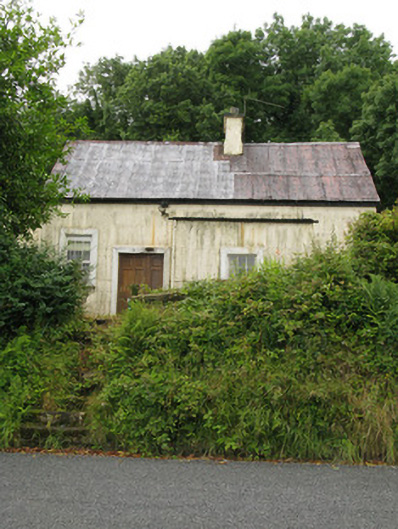
Cantogher Creamery in Gortnaclohy stands entirely dressed in corrugated iron on a raised platform. A shed would have stayed at ground level; this one has climbed onto the table and announced it has a few words to say about butter.
Detached two-bay single-storey with dormer attic corrugated-iron former creamery, built c. 1900, having single-bay lean-to to front (north-east) and single-bay double-height block to side (south-east). Pitched corrugated-iron roof with carved timber bargeboards, rendered chimneystack and cast-iron rain water goods. Corrugated-iron lean-to roofs elsewhere. Corrugated-iron walls with concrete plinth/footing visible throughout. Square-headed window openings with timber surrounds and sills throughout, having six-, eight- and twelve-pane timber casement windows. Single-pane timber casement windows to rear (north-west) elevation with wrought-iron window guards. Square-headed door openings with timber surrounds throughout, having replacement timber panelled door flanked by timber panelled sidelight to front elevation of house and timber battened door to front elevation of additional block. Later single-pitch corrugated-iron outbuildings to north-west. Located within own grounds having rendered square-profile piers with render capping supporting double-leaf wrought-iron gates to south-east. Rendered stepped approach with wrought-iron railing to north-east.
Constructed wholly from corrugated-iron, this former creamery makes a significant contribution to the local architectural heritage. Highly visible from the road and positioned on an elevated platform, the building remains in relatively good repair, with timber casement windows and surrounds enhancing the character of this pleasing building. Simple wrought-iron gates and piers further enhance the visual appeal and make a significant contribution to the historic character of the building.
From the Buildings of Ireland (National Inventory of Architectural Heritage) record 21904406
This does not grant access. Most recorded buildings are privately owned; view them only from public ground unless the owner allows entry.
Places near here
Photo credits
- National Inventory of Architectural Heritage
- A.-K. D., Wikimedia Commons · CC BY-SA 4.0
- Mike Searle, Wikimedia Commons · CC BY-SA 2.0
- Mike Searle, Geograph · CC BY-SA 2.0
- Jonathan Thacker, Geograph · CC BY-SA 2.0
- jonleebotany, Wikimedia Commons · CC0
Mass-rock in GortnaclohyMass-rock · 582 yd Ashford Girls' National SchoolSchool · 655 ydSaint Ita's Catholic ChurchChurch/chapel · 865 ydBallagh MountainMountain / peak · 963 ydGrave YardGraveyard · 1.0 miSaint Ite's WellSpring · 1.1 miGlenquin CastleCastle · 2.0 miGlenduff CastleCastle, tower house · 2.4 miMullaghareirk - Banane LoopWalking route · 3.9 miRock HillMountain / peak · 4.1 miThree CountiesPicnic place · 7.9 miLawson's Cypress11 mi
 Ashford Girls' National SchoolSchool · 655 yd
 Saint Ita's Catholic ChurchChurch/chapel · 865 ydBallagh MountainMountain / peak · 963 ydGrave YardGraveyard · 1.0 mi
 Saint Ite's WellSpring · 1.1 mi
 Glenquin CastleCastle · 2.0 mi
 Glenduff CastleCastle, tower house · 2.4 miMullaghareirk - Banane LoopWalking route · 3.9 miRock HillMountain / peak · 4.1 mi
 Three CountiesPicnic place · 7.9 mi
 Lawson's Cypress11 mi
More historic places in County Limerick · All of County Limerick
What do you know about this place?