
Places near here
Photo credits
- National Inventory of Architectural Heritage
- P L Chadwick, Geograph · CC BY-SA 2.0
- Yablochko, Wikimedia Commons · CC0
- Pierre Terre, Geograph · CC BY-SA 2.0
- Tszabon, Wikimedia Commons · CC BY-SA 3.0
- Schcambo at English Wikipedia, Wikimedia Commons · Public domain
- JP, Wikimedia Commons · CC BY-SA 2.0
- Rafesmar, Wikimedia Commons · CC BY-SA 4.0
- Joseph Mischyshyn, Wikimedia Commons · CC BY-SA 2.0
- Klondikeger, Wikimedia Commons · CC BY-SA 4.0
- User:Mmparedes, Wikimedia Commons · CC BY-SA 2.5
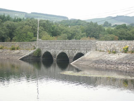 Waters BridgeBridge · 498 yd
Explorer Tom Waters Bridge in Knockraheen is part of the Lower Vartry Reservoir system from 1868, and it claims to hear every secret whispered by the water flowing beneath its arches. It’s functional but not unattractive, so just listen closely as you cross and see if it shares any juicy gossip about the local wildlife.
 hotel572 yd
Explorer Tom Hotel in Togher Beg is where a love story went horribly wrong next to the parking lot. It used to be the Royal Hotel, serving dinner for pennies and dreams for free, but now it’s just a pub with a past. If you hear screaming, don’t look over; that’s just the building remembering what it was like to be famous.
 Victor's WayHeritage attraction · 1.2 mi
Explorer Tom Victor's Way is home to a giant who only appears when you’re holding a half-eaten sandwich. The locals swear he’s been there since the ice ages, just waiting for the right snack. Stand still and listen, the wind tells it better than me.
 J.b. Malone MemorialMemorial · 3.1 mi
Explorer Tom J.B. Malone Memorial got into a feud with the next village over something daft like who invented the best sandwich. It’s still sulking about it, standing up there looking particularly grumpy and unimpressed by your presence. Perfect spot to practise your best tour-guide voice, because you’re going to need it soon.
 Lough TayMountain lake · 3.1 mi
Explorer Tom Lough Tay has an imaginary twin across the sea that owes it rent money. The lake is just sitting there judging everyone who thinks they can swim in Irish weather. Wave at the cows, they're the real locals.
 White HillMountain / peak · 3.5 mi
Explorer Tom White Hill is currently in a furious dispute with the fairies over who gets to park their little cloud-chairs there. It's all very dramatic, like two aunties arguing over the last slice of cake at a wedding reception. Ideal place to rehearse an excuse for being late to work tomorrow.
 LuggalaMountain / peak · 3.6 mi
Explorer Tom Luggala in County Wicklow has a long-standing grudge with the weather because every time it tries to show off its view over Lough Tay, the clouds decide to sulk. It’s like watching a magician pull a rabbit out of a hat except the rabbit is just more fog and disappointment. Stick around for the light changing, it's a show.
 Devil's Glen WaterfallWaterfall · 3.6 mi
Explorer Tom Devil’s Glen Waterfall would teach history by just screaming at you until you stopped asking questions and started paying attention to the rocks. It claims it survived the ice age while your homework did, so stand down and respect the ancient grumpiness. Bring wellies and low expectations, leave delighted.
 CloigtheachRound tower · 5.9 mi
Explorer Tom Cloigtheach in Sevenchurches would tell you in a job interview that he has excellent stability and zero need for a desk. He’s thirty metres of pure granite attitude, standing there while the wind tries to push him over. Stand still and listen, the wind tells it better than me.
 G. YardGraveyard · 5.9 mi
Explorer Tom G. Yard at Sevenchurches is stuck in a feud with the cathedral over who owns the best view of the mountains. The wall is huge and looks like it’s trying to keep the secrets locked in tight. A good place to forget your phone for ten minutes.
 Glen of the DownsNature reserve · 6.4 mi
Explorer Tom Glen of the Downs looks like somebody cut a green passage through Wicklow and forgot to tell the trees to stop growing. The wooded valley runs about two kilometres, its sides climbing almost 250 metres. Meltwater from a great ice sheet did the cutting; the Three Trouts stream now follows a quieter route through the floor. A 59-hectare nature reserve protects part of it. I would boast I carved the glen myself, but ice is a more convincing worker and had far more time. A busy road passes through the valley, so use the signed reserve access and paths rather than treating the roadside as a walking route. Check current trail conditions and keep to safe ground in wet weather. Listen for water once the traffic fades. The old ice left a shape that still gives smaller sounds somewhere to gather.
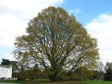 Chestnut-leaved Oak6.4 mi
Explorer Tom Chestnut-leaved Oak would tell a teenager that the 1800s were basically just people wearing funny hats and complaining about the weather for two hundred years straight. It’s got leaves that look like chestnuts but taste like regret if you’re not careful with them. Practise your Irish on it, it won't correct you.
More things to do in County Wicklow · All of County Wicklow

What do you know about this place?Tap to add a comment or ask a question