About this business
From OpenStreetMap (© OpenStreetMap contributors) way 954074890
Places near here
Photo credits
- P L Chadwick, Geograph · Creative Commons Attribution-ShareAlike 2.0
- National Inventory of Architectural Heritage
- Kieran Evans, Geograph · CC BY-SA 2.0
- N Chadwick, Geograph · CC BY-SA 2.0
- Kenneth Allen, Wikimedia Commons · CC BY-SA 2.0
- Kenneth Allen, Geograph · CC BY-SA 2.0
- P L Chadwick, Geograph · CC BY-SA 2.0
- John Daye at en.wikipedia, Wikimedia Commons · CC BY-SA 3.0
- Rossographer, Geograph · CC BY-SA 2.0
- Rossographer, Wikimedia Commons · CC BY-SA 2.0
- Joseph Mischyshyn, Wikimedia Commons · CC BY-SA 2.0
 Saint Patrick's Church (Tullaghobegly)Church/chapel · 266 yd
Explorer Tom Saint Patrick's Church in Tullaghobegly looks like it is trying very hard to reach the sky. The three-stage tower, added in 1914, stands taller than the rest of the building from c.1844, making it look like a lopsided pencil stuck in an eraser. I bet it is secretly measuring how much taller it can grow before it tips over.
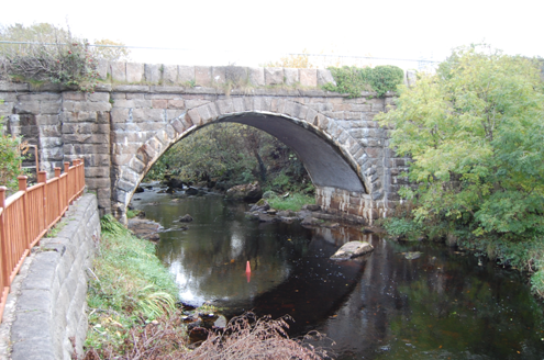 Droichead na Cláidí [Clady Bridge]Bridge · 339 yd
Explorer Tom Droichead na Cláidí [Clady Bridge] was built around 1870 with one round arch and oversized stone parapets over the Clady River. An earlier bridge appears on an old map, and parts of it may be reused here. I thought I had one bridge; the older one might still be tucked inside.
 Trá Dún MórBeach / strand · 1.1 mi
Explorer Tom Trá Dún Mór means big fort beach; perhaps there are ancient stone remnants or just a sense of grandeur in Donegal.
 Braade StrandBeach / strand · 2.0 mi
Explorer Tom Braade Strand has some water sitting behind the beach. I reckon the tide just got confused about which way is up there.
 CarrickfinnOfficial bathing water · 2.4 mi
Explorer Tom Carrickfinn brought a beach and then sneaked a meadow in behind it. Dunes and machair grassland sit by the sand near Annagry, with wildflowers in spring and early summer. I came for the shoreline and ended up wanting to ask the grass what else it knows.
 Stone Circle near Donegal AirportPublicly named stone circle · 2.4 mi
Explorer Tom Stone Circle near Donegal Airport is sitting on the flattest patch of earth I’ve ever seen. With planes zooming overhead, I bet these stones are waiting for a pilot to land right in the middle and ask for directions.
 Sharkey’s BarPub · 2.9 mi
Explorer Tom Sharkey’s Bar in Annagary is a pub that sounds like it has a very opinionated owner named Sharkey. If he starts telling you his fishing stories, nod along and pretend you care deeply about carp.
 Danny Minnie'sRestaurant · 2.9 mi
Explorer Tom Danny Minnie’s must be a restaurant run by two very confused people who forgot their last names. Expect a menu item called 'Confusion' with extra garlic.
 GabhlaIsland · 3.1 mi
Explorer Tom Gabhla has its old houses tucked along the sheltered east side while the western hills take the weather. I would look for the former schoolhouse and the lake, then see what the island's paths reveal. The first adventure is practical: confirm a boat before you pack.
 Annagary HillMountain / peak · 3.3 mi
Explorer Tom Annagary Hill. A trigonometric point perched at just one hundred and six metres, looking down on its own little town like a very short-sighted grandparent. I reckon the view is mostly rooftops and a bit of sky.
 Cairn, CronalaghtPublicly named cairn · 3.5 mi
Explorer Tom Cairn, Cronalaght is just a name on a page right now. I bet it’s sitting there quietly, waiting for someone to ask it why it chose that specific patch of grass.
 Inis OirthirIsland · 4.2 mi
Explorer Tom Inis Oirthir saw its population skyrocket to forty-three in 1901 before everyone quietly vanished by 1956. That is a faster exit than most office parties, don’t you think?
What do you know about this place?Tap to add a comment or ask a question