What is recorded here
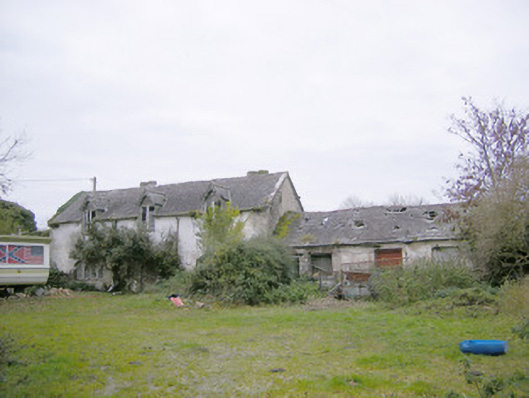
Farmyard complex comprising multiple-bay two-storey buildings, built c. 1790, arranged around a yard. Remains of country house, now in a complete state of ruin, depicted by roughly dressed limestone wall. Remains of pitched slate roofs with red brick chimneystacks. Rendered rubble stone walls. Square-headed openings having red brick voussoirs, limestone sills and remains of timber fittings. Elliptical-headed carriage-arches with red brick voussoirs to site. Detached three-bay two-storey former laundry to north-east of site. Pitched slate roof with rendered chimneystacks and cast-iron rainwater goods. Roughcast rendered walls. Half-dormer window openings to first floor with timber casement windows and timber bargeboards. Segmental-headed openings set in shallow recesses to ground floor with timber lattic casement windows. Square-headed opening with timber panelled door flanked by sidelights having lattic glazing. Set within rubble limestone demesne walls.
Cahir Guillamore was formerly a two-storey late seventeenth-century house with a high roof with dormers and had projecting end bays. The house has been totally destroyed save for the courtyard of outbuildings and laundry house, which are of clear architectural design. Simple in form, the outbuildings form a pleasing group of functional structures which would once have served a large demesne. The laundry building exhibits architectural detailing especially apparent in its half dormer and lattic windows. Set within the former demesne walls, they form a pleasing group of demesne related structures.
This does not grant access. Most recorded buildings are privately owned; view them only from public ground unless the owner allows entry.
Places near here
 Cahir GuillamoreHouse, 17th century · 58 yd
 Burial in Rockbarton (smallcounty By.)Burial · 240 yd
 Field system in Cahirguillamore (smallcounty By.)Field system · 383 yd
 RoadRoad, road/trackway · 875 yd
 CastleCastle, unclassified · 905 yd
 Bawn in Grange (smallcounty By.)Bawn · 1.0 mi
 Lough GurVisitor information · 1.2 mi
 Grange Stone CircleArchaeological place · 1.3 mi
 European ashEuropean ash · 4.3 mi
 Villiers WellSpring · 4.6 mi
 KnockainyMountain / peak · 4.7 mi
 Flat cemetery in Knockainy WestFlat cemetery · 5.7 mi
Other information
Photo: National Inventory of Architectural Heritage · Website use allowed for educational or private purposes with source credit