What is recorded here
From OpenStreetMap (© OpenStreetMap contributors) n3216080584
Places near here
Photo credits
- Roger Diel, Geograph · CC BY-SA 2.0
- Simon Huguet, Wikimedia Commons · CC BY-SA 2.0
- GenesisNZ, Wikimedia Commons · CC BY-SA 4.0
- National Inventory of Architectural Heritage
- Chris, Geograph · CC BY-SA 2.0
- Richard cattel, Geograph · CC BY-SA 2.0
- Gordon Hatton, Geograph · CC BY-SA 2.0
- Charles W Glynn, Wikimedia Commons · CC BY-SA 2.0
Explorer Tom This coastal Promontory fort near Doolin could be a spot where the sea and ancient walls share a quiet conversation.
 Caherrush Castle (in Ruins)Castle, tower house · 58 yd
Explorer Tom Caherrush Castle sits quietly near Spanish Point, and you must check with the landowner before stepping onto this private tower house.
 Emlagh PointHeadland · 1212 yd
Explorer Tom Emlagh Point is a headland in County Clare, perhaps offering a panoramic view of the bay and the western coastline ahead.
 Spanish Point BeachBeach / strand · 1610 yd
Explorer Tom Spanish Point Beach is an extensive sandy stretch west of Milltown Malbay, though you’ll need to watch the bye-laws.
 Bealaclugga BridgeBridge · 1.1 mi
Explorer Tom Bealaclugga Bridge’s mock loopholes make it look like a tiny fortress guarding the river since 1824!
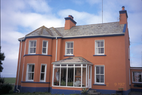 Atlantic LodgeCoastguard station · 1.1 mi
Explorer Tom Imagine Atlantic Lodge watching the sea from Breaffy South, its canted bay window a curious eye on the waves.
 Spanish PointVisitor information · 1.1 mi
 Seafield North BeachBeach / strand · 2.1 mi
Explorer Tom Seafield North Beach gives views of Seafield harbour and Mutton Island in the distance, perfect for a wander.
 Tromra CastleCastle, tower house · 2.3 mi
Explorer Tom Tromra Castle stands proudly on level marshy ground, keeping a close, curious eye on the distant Mutton Island to the northwest.
 Lurga PointHeadland · 2.3 mi
Explorer Tom Lurga Point stretches boldly toward Mutton Island, where the rocky reef meets the ocean in a splashy, wild embrace.
 Freagh IslandIslet · 3.0 mi
 Mutton IslandIsland · 3.2 mi
More cliffs, bays and coast in County Clare · All of County Clare
What do you know about this place?