What is recorded here
Near the bottom of a S-facing slope with good views to the E, SE and W. Hachured and named ‘Cahermore’ on the 1840 and 1916 OS 6-inch maps. Listed as ‘enclosure’ in the RMP (1996). O’Donovan (Comber 1997, 15) recorded it in 1839, as ‘Cahirmore’ and ‘of thirty six yards in diameter, built of very large well shaped…
Read the whole record
From the National Monuments Service (Archaeological Survey of Ireland) record CL016-052001
Places near here
Photo credits
- Night of the Big Wind, Wikimedia Commons · CC BY-SA 3.0 nl
- Andreas F. Borchert, Wikimedia Commons · CC BY-SA 4.0
- Martin Kerans, Geograph · CC BY-SA 2.0
- Joseph Mischyshyn, Wikimedia Commons · CC BY-SA 2.0
- National Inventory of Architectural Heritage
- Adrian King, Geograph · CC BY-SA 2.0
- Bob Jones, Geograph · CC BY-SA 2.0
- Colin Park, Geograph · CC BY-SA 2.0
- N Chadwick, Geograph · CC BY-SA 2.0
- Roger Diel, Geograph · CC BY-SA 2.0
- Joseph Mischyshyn, Geograph · CC BY-SA 2.0
 Cross in RoughanCross · 72 yd
Explorer Tom Lean against this fragment of a cross shaft from Roughan and wonder if it truly was part of the famous Tau cross nearby.
 CarnWedge tomb · 1.1 mi
Explorer Tom Up on Roughan Hill, this Carn sits proudly on exposed limestone pavement, offering you a spectacular sweep of views from the southeast to northwest.
 Leamaneh Castle (in ruins)Castle, tower house · 1.3 mi
Explorer Tom Five stories of limestone in Leamaneh North, where the missing garderobes make me wonder if 15th-century castle life was surprisingly low-key.
 Leamaneh CastleCastle · 1.3 mi
Explorer Tom Leamaneh Castle was built about 1480 as a basic multi-storied Irish tower house, later surrendered to Henry VIII.
 Kilinaboy Church (in ruins)Church · 1.3 mi
Explorer Tom Kilinaboy Church overlooks a shallow valley, built by or for Iníon Baoith, preserving its oblong shape beautifully.
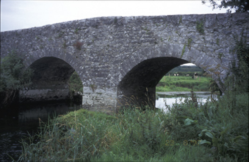 Poplar BridgeBridge · 1.4 mi
Explorer Tom Poplar Bridge in Crossard is a double-arch hump-back structure from about 1810, spanning the river with cut-stone voussoirs.
 Inchiquin IslandIslet · 2.1 mi
Explorer Tom Inchiquin Island! A small islet with a name that sounds like it could be part of a royal lineage, what secrets does it keep in County Clare?
 Rock IslandIsland · 2.2 mi
Explorer Tom Rock Island, with its rugged silhouette, stands proudly near Lough Inchiquin’s southern shore.
 Burren Centre KilfenoraVisitor information · 4.3 mi
Explorer Tom Burren Centre Kilfenora is a haven for those seeking the beauty of the Burren in County Clare
 High CrossHeritage attraction · 4.3 mi
Explorer Tom High Cross: an ancient landmark where faith and heritage stand tall in County Clare
 Cave of the Wild HorsesCave · 4.6 mi
Explorer Tom Cave of the Wild Horses sits six kilometers west of Carran, evoking images of untamed creatures in the dark.
 Poulnabrone - Burren GeositeVisitor information · 4.9 mi
Explorer Tom Poulnabrone - Burren Geosite has me thinking it's a place where the earth has a special shape; the account doesn't say what's special about it.
More archaeology and monuments in County Clare · All of County Clare

What do you know about this place?Tap to add a comment or ask a question