What is recorded here
From the National Monuments Service (Archaeological Survey of Ireland) record CL025-003
Places near here
Picture notes
- Computer-made picture. It does not show this monument.
- The Banner, Wikimedia Commons · CC BY-SA 4.0
- National Inventory of Architectural Heritage
- Odea at English Wikipedia, Wikimedia Commons · Public domain
- Computer-made picture. It does not show this mountain top.
- Computer-made picture. It does not show this playground.
- Adrian King, Geograph · CC BY-SA 2.0
- Bob Jones, Geograph · CC BY-SA 2.0
- Willow, Wikimedia Commons · CC BY 2.5
- Martin Kerans, Geograph · CC BY-SA 2.0
 Fairy fort / earthen ringfort in Carnaun (inchiquin By.)Fairy fort / earthen ringfort · 816 ydComputer-made picture
Explorer Tom This Carnaun ringfort is actually run by a dog named Kevin who answers to no one. He’s in charge of the perimeter and he’s not bluffing. Bring a flask and pretend you own the place, but keep an eye out for Kevin’s tail.
 Ritual siteRitual site, holy/saint's stone · 831 ydComputer-made picture
Explorer Tom Ritual site in Shessiv is a stone that locals swear will break your luck if you look at it sideways. Ideal stop for a big stretch and a bigger yawn while you pretend to be serious about superstition.
 Saint Mary's Catholic ChurchChurch/chapel · 1125 yd
Explorer Tom Saint Mary's Catholic Church in Roxton is a solid 1870 structure with a sacristy on the right, probably for keeping secrets. The rock-faced stone walls look tough, but I bet it’s got a soft spot for gossip. Tell the next person you meet it's haunted. It might be.
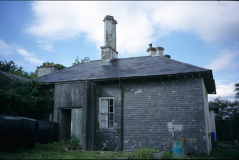 AdelphiHouse · 1.5 mi
Explorer Tom Adelphi in Clifden has a basement that’s only partly raised, which is either clever or just lazy architecture from 1810. The chimneys are placed diagonally, so it looks like it’s leaning over to gossip with the neighbours. Bring a coin for luck and keep it in your pocket.
 O'Dea CastleCastle · 1.7 mi
Explorer Tom O'Dea Castle is a recorded castle in County Clare, with a photo taken by Richard G. O'Dea releasing all rights.
 Clifden HillMountain / peak · 1.9 miComputer-made picture
Explorer Tom Clifden Hill is a quiet sentinel in the landscape, its summit shrouded in mystery and the quiet dignity of the land it guards.
 Children's playground2.0 miComputer-made picture
Explorer Tom This children's playground is a hidden gem where kids can run, play, and explore freely.
 Inchiquin IslandIslet · 2.1 mi
Explorer Tom Inchiquin Island! A small islet with a name that sounds like it could be part of a royal lineage, what secrets does it keep in County Clare?
 Rock IslandIsland · 2.1 mi
Explorer Tom Rock Island, with its rugged silhouette, stands proudly near Lough Inchiquin’s southern shore.
 European ash2.6 mi
Explorer Tom European ash that probably thinks it's a fancy French willow but with better posture. Bring your worst joke, the place has heard worse from my mates.
 KnockloonMountain / peak · 4.3 miComputer-made picture
Explorer Tom Knockloon, a peak that’s got a name that sounds like it was made for a song in County Clare.
 Leamaneh Castle (in ruins)Castle, tower house · 4.6 mi
Explorer Tom Leamaneh Castle in Leamaneh North is showing off its five-storey ego again, thinking it’s too good for the locals. It needs a better agent before it ends up in a tourist brochure, so get a photo with it first.
More archaeology and monuments in County Clare · All of County Clare

What do you know about this place?Tap to add a comment or ask a question