What is recorded here
From OpenStreetMap (© OpenStreetMap contributors) n1496460061
Places near here
Photo credits
- National Inventory of Architectural Heritage
- kevin higgins, Wikimedia Commons · CC BY-SA 2.0
- Tim Sheerman-Chase, Wikimedia Commons · CC BY 2.0
- Jonathan Thacker, Geograph · CC BY-SA 2.0
- Mike Searle, Wikimedia Commons · CC BY-SA 2.0
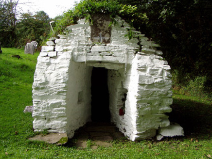 Saint Abigail's WellHoly well · 2.4 mi
 St Abigails WellHoly well · 2.4 mi
Explorer Tom St Abigails Well is enclosed by a D-shaped corbelled structure at Kilgobnet. There’s an inscription about expelling the plague in 1872. People still do rounds here, so it’s got some serious energy.
 Knockduff Wind FarmVisitor information · 2.7 mi
 LisheentoortaghFairy fort / earthen ringfort · 2.8 mi
Explorer Tom Lisheentoortagh is called 'Little fort of the Royal Palace' by Bowman, which is a bit grand for a ringfort. It has a proper entrance and trees planted outside. It’s trying very hard to be important.
 Lacka BridgeBridge · 2.9 mi
 Eagle's NestMountain / peak · 2.9 mi
 Mount HillaryMountain / peak · 4.3 miGurteenkreen Castle (Site of)Castle, unclassified · 4.9 mi
Explorer Tom Gurteenkreen Castle has vanished from the flat pasture. A 1907 photo shows it covered in ivy with a house built against it. Now? Just grass and speculation. It’s like the castle went on holiday and never came back. Typical Irish ghost story.
 New TipperaryVisitor information · 4.9 mi
 Dromaneen CastleHeritage attraction · 4.9 mi
 Dromaneen Castle (in Ruins)House, fortified house · 4.9 mi
Explorer Tom Dromaneen Castle sits atop a cliff edge overlooking the Blackwater River. It was an O'Callaghan fortified house built on an earlier castle site. The MacDonagh MacCarthys were the overlords, which sounds like a very dramatic family reunion gone wrong.
 Mount Hillary - Father Murphy LoopWalking route · 5.1 mi
More mountains and hills in County Cork · All of County Cork
What do you know about this place?Tap to add a comment or ask a question