What is recorded here
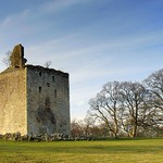
Busby, The Peel is a tower house in South Lanarkshire, Scotland.
Places near here
Photo credits
- Maker not stated on source page, www.flickr.com
- Iain Thompson, Wikimedia Commons · CC BY-SA 2.0
- Stephen Sweeney, Wikimedia Commons · CC BY-SA 2.0
- Mark Nightingale, Wikimedia Commons · CC BY-SA 2.0
- Richard Sutcliffe, Wikimedia Commons · CC BY-SA 2.0
- Maker not stated on source page, www.dreamstime.com
- Andrew Reid, Wikimedia Commons · CC BY-SA 2.0
- Maker not stated on source page, commons.wikimedia.org
 Castle HillCastle (medieval) · 440 yd
 ThorntonhallWeir · 712 yd
 BraeheadLime Kiln(s) (post Medieval) · 863 yd
 BusbysideByre (post Medieval), Farmstead (post Medieval), Pen (post Medieval), Well (possible) · 877 yd
 Philipshill, Westerfield Road, CemeteryCemetery (20th Century) · 883 yd
 Philipshill CemeteryCemetery · 904 yd
 Glasgow, Kittoch BridgeRoad Bridge · 948 yd
 Woodland by the Carmunnock BypassForest or wood · 1123 yd
 Peel Road, ThorntonhallNo Class (event) · 1185 yd
 Busby, Carmunnock Road, the Auld KirkChurch (19th Century) · 1186 yd
 Glasgow, Carmunnock, Pathhead Road, GeneralGeneral View · 1456 yd
 Moot Hill of DrippsWood · 1.1 mi
More castles and forts in South Lanarkshire · All of South Lanarkshire

What do you know about this place?Tap to add a comment or ask a question