
What is recorded here
Peel Road, Thorntonhall is a historic event in South Lanarkshire, Scotland.
From the Historic Environment Scotland record 369000
The historic-place record does not grant public access. Check current conditions and ownership before entering land or a building.
Places near here
 ThorntonhallNo Class (event) · 333 yd
 Thorntonhall StationRailway Station (19th Century) - (20th Century) · 361 yd
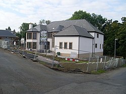 ThorntonhallGate Post(s) · 517 yd
 ThorntonhallWeir · 620 yd
 Meikle DrippsMoot Hill (possible), Mound · 871 yd
 Busby LibraryMemorial · 1559 yd
 Philipshill, Westerfield Road, CemeteryCemetery (20th Century) · 1694 yd
 Flenders RockMountain / peak · 1.2 mi
 Woodland by the Carmunnock BypassForest or wood · 1.2 mi
 Jackton, Eaglesham RoadNo Class (event) · 1.3 mi
 National Museum of Rural LifeMuseum · 1.4 mi
 Greenbank GardenMuseum · 1.8 mi
Pictures: Alec MacKinnon, Wikimedia Commons · CC BY-SA 2.0; Richard Webb, Wikimedia Commons · CC BY-SA 2.0; Stephen Sweeney, Wikimedia Commons · CC BY-SA 2.0; Iain Thompson, Wikimedia Commons · CC BY-SA 2.0; G McK, Wikimedia Commons · CC BY-SA 2.0; Richard Sutcliffe, Wikimedia Commons · CC BY-SA 2.0; Leslie Barrie, Wikimedia Commons · CC BY-SA 2.0; Billy McCrorie, Wikimedia Commons · CC BY-SA 2.0; thejackrustles, Wikimedia Commons · CC BY-SA 2.0
More wrecks and historic events in South Lanarkshire · All of South Lanarkshire
What do you know about this place?