
What is recorded here
From OpenStreetMap (© OpenStreetMap contributors) w377430580
Places near here
Photo credits
- Colin Kinnear, Wikimedia Commons · CC BY-SA 2.0
- Phil Catterall, Wikimedia Commons · CC BY-SA 2.0
- Richard Webb, Wikimedia Commons · CC BY-SA 2.0
- Steven Brown, Wikimedia Commons · CC BY-SA 2.0
- Oliver Dixon, Wikimedia Commons · CC BY-SA 2.0
- Maker not stated on source page, commons.wikimedia.org
- James Denham, Wikimedia Commons · CC BY-SA 2.0
- Milestone Society, Wikimedia Commons · CC BY-SA 2.0
 Back HillMountain / peak · 971 yd
 Hightown HillHut Circle (prehistoric) (possible) · 1385 yd
Explorer Tom Hightown Hill has a long list of former names, but they all sound like variations of 'that hill over there' with extra…
 Hempland HillFarmstead · 1599 yd
Explorer Tom Hempland Hill in Dumfries and Galloway claims to be older than the concept of time itself, which is a wild stretch even…
 DamheadFarmstead · 1.0 mi
Explorer Tom Damhead in Dumfries and Galloway is currently in a legal dispute with some very small fairies over parking rights. I…
 South CowshawFlat Axehead (bronze) · 1.1 mi
Explorer Tom South Cowshaw has a flat bronze axehead that’s probably been sitting there listening to bad poetry written by someone…
 TinwaldshawsFarmhouse · 1.2 mi
Explorer Tom Tinwaldshaws is sitting out there in Dumfries and Galloway like a farmer who forgot his own birthday. It’s listed as…
 Crochmade WoodWood · 1.3 mi
 Tinwald HouseHouse (18th Century) (1740) · 1.5 mi
Explorer Tom Tinwald House built itself in 1740, which is impressive considering it still looks like it hasn’t decided what century…
 AmisfieldFlake (flint) · 1.5 mi
Explorer Tom Amisfield also has this flint flake that looks like it was chipped off a bigger argument between two lads in a pub…
 Trailflat, Old Parish ChurchBurial Ground (medieval), Church (medieval), Grave Slab (15th Century), Rubbing Stone (post Medieval) · 1.6 mi
Explorer Tom Trailflat, Old Parish Church is having a quiet rivalry with every other church in Galloway. It’s got a 15th-century…
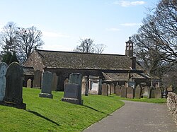 TinwaldBurial Ground (20th Century) · 1.6 mi
Explorer Tom Tinwald has a burial ground that seems to have a long-standing grudge against the weather. It’s been sitting there…
 Ryemuir WoodWood · 1.7 mi
More woods, forests and old trees in Dumfries and Galloway · All of Dumfries and Galloway

What do you know about this place?Tap to add a comment or ask a question