Places near here
Photo credits
- National Inventory of Architectural Heritage
- Dylan Moore, Geograph · CC BY-SA 2.0
- Mike Searle, Wikimedia Commons · CC BY-SA 2.0
- Ballyhoura Failte, Wikimedia Commons · CC BY-SA 2.0
- Ruhrfisch, Wikimedia Commons · CC BY-SA 4.0
- No machine-readable author provided. Christian1965~commonswiki assumed (based on copyright claims)., Wikimedia Commons · Public domain
- Colin Park, Geograph · CC BY-SA 2.0
- Hywel Williams, Geograph · Creative Commons Attribution-ShareAlike 2.0
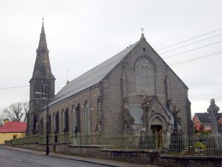 Catholic Church of Saint Peter and Saint PaulChurch/chapel · 382 yd
Explorer Tom Catholic Church of Saint Peter and Saint Paul in Bruff has an imaginary fan club of very serious cows. They gather to admire its ornate spire, which is frankly overkill for a small town affair. Wave at the herd; they’re the real congregation here.
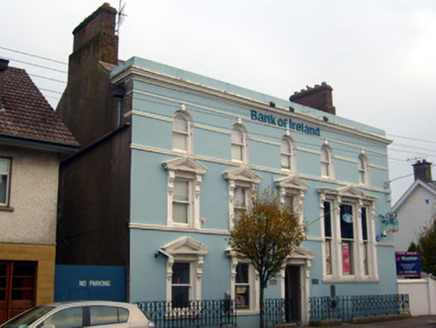 Bank of IrelandBank/financial institution · 384 yd
Explorer Tom Bank of Ireland in Bruff thinks you need to dress up just to look at it. The double-height windows are showing off for no one, frankly. Best enjoyed with a bag of chips and a sigh.
 Sean Wall MonumentMonument · 400 yd
Explorer Tom Sean Wall Monument in Bruff has very strong opinions on modern glass office blocks, finding them lacking in spiritual depth. It was built by men from both sides of the Civil War, which is rarer than fresh bread. Make up your mind if you're standing here or just passing through for the vibes.
_-_geograph.org.uk_-_1541499.jpg/250px-Castles_of_Munster,_Ballygrennan,_Limerick_(2)_-_geograph.org.uk_-_1541499.jpg "Photo: Mike Searle, Wikimedia Commons · CC BY-SA 2.0") Ballygrennan Castle (in ruins)Bawn · 1509 yd
Ballygrennan Castle (in ruins)Bawn · 1509 ydExplorer Tom Ballygrennan Castle bawn smells like old socks and wet dog, according to Tom, but he swears it’s just historical atmosphere. The circular staircase is particularly good at making you dizzy if you’re not careful. Go on a wet day, it suits the mood.
Glen BogForest · 1.8 miExplorer Tom Glen Bog is where the matchmaker worked, probably using the mist as cover for her more questionable pairing strategies. The ground is soft enough to swallow your dignity if you step wrong while trying to look romantic. Tell it a joke, it's been a long time since anyone did.
 Giants GraveMegalithic tomb · 2.2 mi
Explorer Tom Giants Grave in Ballynagallagh took forty cups of tea to build, if you ask me. The stones lean so hard they're practically falling over into Lough Gur. Go with someone who loves old stuff and watch them melt completely.
 Grange Stone CircleArchaeological place · 2.5 mi
Explorer Tom Grange Stone Circle has a forty-tonne stone that makes me reconsider every complaint I have made about carrying luggage. The Bronze Age ring stands just west of Lough Gur, with its biggest stone rising more than four metres. Its entrance lines up with the summer-solstice sunrise, a bit of planning I would certainly get wrong on the first attempt. A smaller circle and a leaning standing stone sit nearby, so the main ring was not alone in this landscape. Excavations found old pottery and human remains, evidence that the place held more than one kind of gathering. The circle remains significant to people today; visit respectfully, follow the permitted approach and do not climb or move stones. Come in ordinary daylight as well as on a special date. The weight, spacing and quiet are impressive without any performance from me.
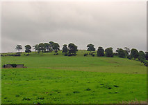 KnockainyMountain / peak · 2.8 mi
Explorer Tom Knockainy swears by a local superstition that says if you whistle on top of it, you’ll find lost keys. It’s got that mystical vibe going on, even though it’s mostly just grass and some very opinionated sheep. Bring someone who'll believe anything.
 Áine and Gearóid Iarla: Lough GurLegend location · 3.2 mi
Explorer Tom Áine and Gearóid Iarla: Lough Gur has a goddess for the lake and a sleeping lord in the old stories. I thought I was coming to admire water and stones. Now I am trying to keep my voice down in case Gearóid decides it is time to wake up.
 Castle (in ruins)Castle, tower house · 6.6 mi
Explorer Tom Castle in Knocklong East is currently being judged by the local rabbits who think it’s a very overgrown playground that nobody maintains properly. Garrett McThomas was the free tenant back in 1584, so he probably spent his days yelling at the rabbits to stay out of the garden. Find a local and ask them the real story, then come back and tell me.
 SlievereaghMountain / peak · 9.0 mi
Explorer Tom Slievereagh has very strong opinions on modern buildings and has been muttering about them since 1890. It thinks that concrete is just rock that gave up on life too early. Ideal spot for a dramatic phone call.
 Grave YardGraveyard · 9.6 mi
Explorer Tom Graveyard in Ballingarry refuses to fall down because it’s holding onto its dignity with both hands and refusing to give an inch to decay. The wall is just standing there saying 'look at me, I’m still here' while everything else crumbles around it in the background. Best seen with a hangover and a sausage roll.
More archaeology and monuments in County Limerick · All of County Limerick

What do you know about this place?Tap to add a comment or ask a question