
Places near here
Photo credits
- Mike Searle, Wikimedia Commons · CC BY-SA 2.0
- JohnArmagh, Wikimedia Commons · CC BY-SA 3.0
- National Inventory of Architectural Heritage
- Wanfried-Dublin, Wikimedia Commons · CC BY 4.0
- The Banner, Wikimedia Commons · CC BY-SA 3.0
- Jackieray at English Wikipedia, Wikimedia Commons · Public domain
- Willow, Wikimedia Commons · CC BY 2.5
- Joseph Mischyshyn, Geograph · CC BY-SA 2.0
- C Michael Hogan, Geograph · CC BY-SA 2.0
- PaulT, Wikimedia Commons · CC BY-SA 4.0
- Roger Diel, Geograph · CC BY-SA 2.0
 Dromore CastleCastle · 1469 yd
Explorer Tom Dromore Castle would review its visitors as 'adequate' because they all stand by the nature reserve car park and take the same exact photo from the same angle every single time. It’s sitting on the edge of Dromore Lough looking unimpressed by your enthusiasm for its reed-fringed inlet surroundings. Stand back, squint, and it looks like a castle.
Dromore Castle (in ruins)Castle, tower house · 1469 ydExplorer Tom Dromore Castle used to be on an island, which sounds like a very expensive holiday home. Teige built it, probably while arguing about who gets the best chair. Ten minutes here and you'll have a yarn for the pub that lasts all night.
 Abbey (in ruins)Religious house, Augustinian canons · 1.6 mi
Explorer Tom Abbey on Inchicronan Island has a ghost that's too lazy to haunt it properly and just naps in the ruins instead. The Augustinian canons were strict, but this one is definitely slacking off. Whisper a secret at it, it's kept worse ones before.
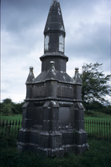 Kelly MausoleumMausoleum · 1.7 mi
Explorer Tom Kelly Mausoleum is from 1882 and has an octagonal shaft with a conical cap that looks like a giant pencil sharpener. It’s got stepped buttresses that are purely for dramatic effect, probably to scare off raccoons. Go at sunset and thank me later when the shadows make it look even spookier.
.jpg/250px-2026.06.25.Caheraphuca_(1).jpg "Photo: Wanfried-Dublin, Wikimedia Commons · CC BY 4.0") Giants GraveWedge tomb · 2.0 mi
Giants GraveWedge tomb · 2.0 miExplorer Tom Giants Grave in Caheraphuca is named after a giant who probably just needed a nap but got stuck instead. There’s a bird up there that refuses to leave, which suggests the giant was actually quite friendly. Take a breath of that air, it’s older than your car, trust me.
.jpg/250px-Church_of_Rath_Blaithmaic_sheela-na-gig_(upside_down).jpg "Photo: The Banner, Wikimedia Commons · CC BY-SA 3.0") Sheela-na-gig in RathSheela-na-gig · 5.8 mi
Sheela-na-gig in RathSheela-na-gig · 5.8 miExplorer Tom Sheela-na-gig in Rath is upside down over a window recess, probably judging your fashion choices. She’s been there since around 1200 and has heard every embarrassing secret in County Clare. Bring a map, get lost anyway, that's the real fun.
 Killone AbbeyHeritage attraction · 8.1 mi
Explorer Tom This other Killone Abbey is having a serious drama with the nearest tree, claiming the roots are trying to steal its foundation. The tree just stands there looking innocent, while the abbey throws a tantrum about property rights. Go back in winter, it's a different animal.
 European ash8.8 mi
Explorer Tom European ash in County Clare was once used for smuggling whiskey, with bottles hidden inside its hollow trunk where no customs officer could ever find them. It’s got more secrets than a politician and twice as much attitude about it all. Find the date carved somewhere and feel clever.
 Poulnabrone - Burren GeositeVisitor information · 12 mi
Explorer Tom Poulnabrone Burren Geosite in County Clare has a prophecy that the stones will dance at midnight, but they’ve been napping for centuries because they’re too tired. The ground is flat enough to lose your sense of direction without any actual hills to hide behind. Bring a flask of something warm and a story to swap.
 The Portal TombVisitor information · 12 mi
Explorer Tom The Monastery of St. Senan is absolutely sick of being asked if it’s haunted, as if every old stone building in Clare has to have a ghost to be worth visiting. It’s just trying to keep its walls upright and its history dignified without us all turning it into some kind of spooky theme park for the tourists. Stick around for the light
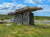 Poulnabrone DolmenHeritage attraction · 12 mi
Explorer Tom You see a tidy little stone sculpture? Those builders had a much heavier job. Poulnabrone Dolmen stands in the Burren like a stone doorway, but this was a burial place, not an invitation to walk through. The name means “Hole of the Quernstone”; “Hole of Sorrows” is a common mistranslation, however tempting it is for a dramatic storyteller. Today you see the stone skeleton. I can embellish a tale, but I cannot turn a quernstone into sorrow just by wishing. Its builders originally covered the chamber with earth and a cairn, so the familiar outline is only part of their design. The capstone rises toward the west, a detail worth noticing from the path. In the twentieth century a crack in a supporting stone kept widening, and careful work in 1986 and 1988 both secured the monument and revealed burials made over many generations. I will leave the people buried here their dignity and keep my jokes for my own poor sense of direction. The limestone ground is rough; stay on the visitor approach and leave the ancient stones untouched. They have carried enough weight already.
 Cave of the Wild HorsesCave · 12 mi
Explorer Tom Cave of the Wild Horses near Carran has an imaginary twin across the sea that never stops complaining about the weather. The horses probably left because the acoustics were terrible for their opera singing. Take the long way round, it deserves the effort.
More archaeology and monuments in County Clare · All of County Clare

What do you know about this place?Tap to add a comment or ask a question