Places near here
Photo credits
- National Inventory of Architectural Heritage
- Oliver Dixon, Wikimedia Commons · CC BY-SA 2.0
- Kmcnamee, Wikimedia Commons · CC BY-SA 4.0
- ., Wikimedia Commons · CC BY-SA 4.0
- Eric Jones, Geograph · CC BY-SA 2.0
- Mike Searle, Geograph · Creative Commons Attribution-ShareAlike 2.0
Explorer Tom Another invisible Broughal enclosure that claims the 1800s were basically just a long lunch break. It would tell your…
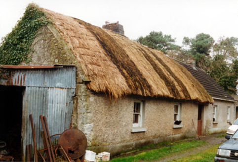 farm house1250 yd
Explorer Tom Farm house in Broughal has a door on the gable end because someone had a very strong opinion about where entrances…
Beach ClumpWood · 1.1 miExplorer Tom Beach Clump would post a picture of itself with a caption about how it’s basically a beach but without the sand or the…
Broughal CastleCastle, unclassified · 1.1 miExplorer Tom Broughal Castle was demolished in the 1930s by the Molloy family, who probably wanted more garden space for their…
 Mesolithic siteRuins · 1.3 mi
Explorer Tom Mesolithic site in County Offaly would tell its younger self to stop poking at the fire and start building something…
 Lough Boora Sculpture ParkMuseum · 2.2 mi
Explorer Tom Lough Boora Sculpture Park places big, strange shapes across Offaly peatland once worked for fuel. One work seems to…
 Kilcormac Killoughey GAA pitchGAA ground · 2.2 mi
 Turf Wind and FireSculpture · 2.6 mi
Explorer Tom Turf Wind and Fire is a sculpture that smells like Sunday afternoon cooking. If it could talk to its younger self, it…
 Coole CastleCastle, tower house · 4.1 mi
Explorer Tom Coole Castle in Coole has four floors and a river view that makes it feel like a VIP lounge. It would tell you after a…
 Cloghan HillMountain / peak · 4.1 mi
Explorer Tom Cloghan Hill in Offaly thinks all tourists from Dublin are just lost actors looking for their next big break. It keeps…
Drumcullen GAA pitchGAA ground · 4.5 mi Grave YardGraveyard · 5.1 mi
Explorer Tom Graveyard in Eglish would survive Big Brother by hiding in the corner and judging everyone’s cooking. It’s full of old…
More historic places in County Offaly · All of County Offaly

What do you know about this place?Tap to add a comment or ask a question