
What is recorded here
From OpenStreetMap (© OpenStreetMap contributors) n4095827663
Places near here
Photo credits
- National Inventory of Architectural Heritage
- Mike Searle, Geograph · CC BY-SA 2.0
- A.-K. D., Wikimedia Commons · CC BY-SA 4.0
- Mike Searle, Wikimedia Commons · CC BY-SA 2.0
- Jonathan Thacker, Geograph · CC BY-SA 2.0
- N Chadwick, Geograph · CC BY-SA 2.0
- Unknown author Unknown author, Wikimedia Commons · Public domain
- PAUL FARMER, Wikimedia Commons · CC BY-SA 2.0
- EecherplazGinkgo06.jpg : Cayambe derivative work: Ginkgotree ( talk ), Wikimedia Commons · CC BY-SA 3.0
- Marathon, Geograph · CC BY-SA 2.0
- Mike Murphy ( talk · contribs ), Wikimedia Commons · CC BY-SA 3.0
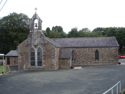 Saint Peter's ChurchChurch/chapel · 3.1 mi
Explorer Tom Saint Peter's Church in Tooreennagrena is dressed to the nines with limestone ashlar and stained glass. Built around 1830, it’s got those high-artistic merit details. It looks like it’s ready for a service. Bow your head in respect!
 Glenduff CastleCountry house · 3.2 mi
 Saint Ite's WellSpring · 4.9 mi
 Glenquin CastleCastle · 5.2 mi
 Three CountiesPicnic place · 5.9 mi
 Templars Castle (in ruins)Castle, Anglo-Norman masonry castle · 9.7 mi
 Bryan MacMahonMemorial · 20 mi
 Lartigue MonorailMuseum · 20 mi
 Red Deer of IrelandSculpture · 25 mi
 Ginkgo25 mi
Explorer Tom This Ginkgo in County Kerry thinks Dublin tourists are loud and wear too many hats. It’s been around longer than their excuses for being late. Sit on a wall near it and pretend you're in a painting.
 Monsignor Hugh O'Flaherty MemorialMemorial · 25 mi
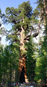 Giant Sequoia25 mi
Explorer Tom A Giant Sequoia in County Kerry would tell teenagers the 1800s were all about slow fashion and no Wi-Fi. It’s definitely not from here, but who cares? Visit, then text me what you think. I'll pretend to read it.
More mountains and hills in County Cork · All of County Cork

What do you know about this place?Tap to add a comment or ask a question