
Places near here
Photo credits
- National Inventory of Architectural Heritage
- N Chadwick, Geograph · CC BY-SA 2.0
- Kenneth Allen, Wikimedia Commons · CC BY-SA 2.0
- Tawg, Wikimedia Commons · CC BY-SA 3.0
- Eric Jones, Geograph · CC BY-SA 2.0
- Didier Descouens, Wikimedia Commons · CC BY-SA 4.0
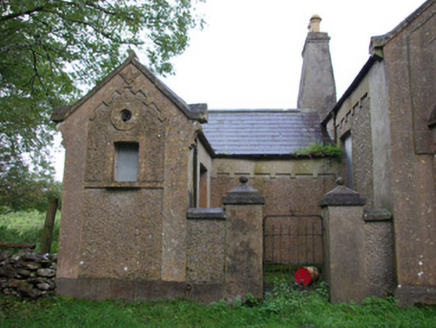 Carricknahorna Masonic HallOrange Hall, masonic lodge/hall · 2.5 mi
Explorer Tom Carricknahorna Masonic Hall makes its purpose hard to miss: a square and compass stand out on the front gable. Its date is less tidy, the record gives 1906 or 1919. I like that it stands beside the Orange Hall, with related decoration to compare.
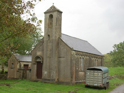 Carricknahorna Orange HallOrange Hall · 2.5 mi
Explorer Tom Carricknahorna Orange Hall has a plaque where someone carved 'Parochial' right over the word 'Orange'. It looks like a very messy game of Scrabble! I wonder if they were in a hurry to cover up the old name.
 C17th church & graveyard at castle caldwell in RossbegC17th Church & Graveyard at Castle Caldwell · 3.1 mi
Explorer Tom C17th church & graveyard at castle caldwell is where a poet fell in a ditch and wrote a bad sonnet about it. The ghosts are probably still arguing over the copyright. Have a look and decide if I was lying about the drama.
 Castle: castle caldwell in RossbegCastle: Castle Caldwell · 3.2 mi
Explorer Tom Castle Caldwell in Rossbeg hears everything you whisper to your mates. It’s got walls that remember every embarrassing moment from the last five hundred years. Bring wellies and low expectations, leave delighted by how much you don't know.
 Castle Caldwell ForestWood · 3.2 mi
Explorer Tom Castle Caldwell Forest was once the escape route for a lord who owed too many debts. He ran through here with nothing but his dignity and a sandwich. Bring a flask and pretend you own the place.
 Battlefield in Cloghore (carrickboy Ed),corlea (pettigo Ed)Battlefield · 3.6 mi
Explorer Tom Battlefield in Cloghore, Corlea is a spot where two armies argued so loud the trees moved to avoid the noise. It's basically a giant historical tantrum waiting for your attention. Snap one photo, then put the phone away and actually look at what you've found.
 Battle of BelleekBattle · 3.7 mi
Explorer Tom Battle of Belleek, also called the Battle of the Erne Fords, took place at a River Erne crossing near Belleek on 10 October 1593. Hugh Maguire's defenders faced Henry Bagenal's English Crown force. I want to point at the exact ford, but that would be Tom bluffing: this marker shows the general area, and no battlefield boundary has been surveyed.
 Belleek PotteryHeritage attraction · 3.7 mi
Explorer Tom Belleek Pottery in County Fermanagh is writing its dating profile right now: 'I make pretty blue things, I’m slightly pretentious, don’t mind.' It’s a heritage spot that thinks it’s way more fancy than a local pottery really needs to be. Bring a notebook and write the bit I made up.
 Belleek Pottery MuseumMuseum · 3.7 mi
Explorer Tom Belleek Pottery Museum in County Fermanagh refuses to fall down because it knows it has the best ceramic gossip in the entire county. It stands there on its own little hill, judging your shoe choices while you try to figure out what’s behind the door. Tell me if the gossip I made up is true.
 MuckinishIsland · 3.8 mi
Explorer Tom Muckinish is incredibly proud of its ability to smell like damp socks and ancient secrets, which is quite an achievement considering how little it actually does. It thinks it’s mysterious, but really it just looks like a big green cushion floating in the middle of nowhere else. It's the kind of place that makes a dull Tuesday interesting.
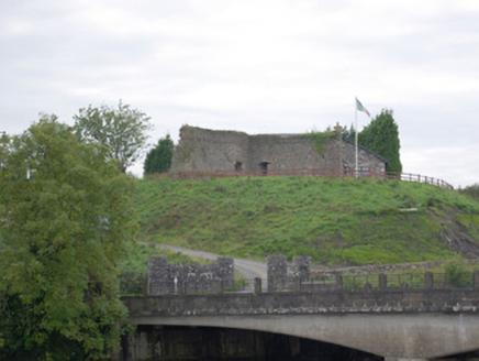 Belleek Battery / FortBattery and garrison fort · 3.8 mi
Explorer Tom Belleek Battery / Fort was raised right after the 1798 rebellion to guard the crucial bridge at Cloghgore. It’s now a battered stone mess, partly joined to someone’s private home, which is a bit cheeky of them. Those firing holes make me imagine the border guards from the 1920s staring right back.
 Hawthorn4.3 mi
Explorer Tom Hawthorn in County Donegal made a New Year's resolution to grow more thorns but ended up growing way too many and now nobody can hug it properly. It’s got that prickly attitude that keeps everyone at arm's length, which is honestly quite refreshing after all the hugging. Have a chat with it, nobody's watching.
More mountains and hills in County Donegal · All of County Donegal

What do you know about this place?Tap to add a comment or ask a question