What is recorded here
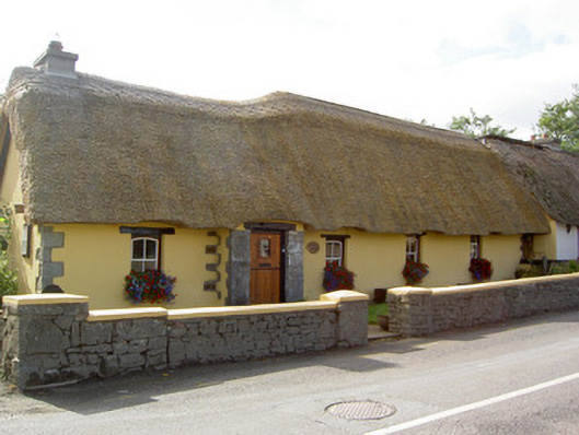
Semi-detached five-bay single-storey house, built c. 1880, with single- and two-storey extensions to rear, windbreak to entrance and incorporating fabric of earlier dwelling. Pitched thatched roof, reed to outer layers, some straw remaining beneath. Replacement timber bargeboard to gable end and rendered chimneystack.…
Read the whole record
From the Buildings of Ireland (National Inventory of Architectural Heritage) record 20900703
Places near here
Picture notes
- National Inventory of Architectural Heritage
- Computer-made picture. It does not show this monument.
- Computer-made picture. It does not show this playground.
- Mike Searle, Wikimedia Commons · CC BY-SA 2.0
- Unknown author Unknown author, Wikimedia Commons · Public domain
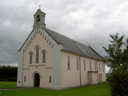 Saints Peter and Paul ChurchChurch/chapel · 695 yd
Explorer Tom Saints Peter and Paul Church in Dromina dates to 1936 and has some very fancy machicolation-type detailing. It sits on an elevated position, looking down at the village like a gentle giant. The render is textured enough to feel with your eyes.
 Fairy fort / earthen ringfort in Farthingville EastFairy fort / earthen ringfort · 734 ydComputer-made picture
Explorer Tom Fairy fort in Farthingville East has been ploughed within the last 30 years, so it’s seen some action. It’s a low rise now, abutting a field fence. See if you can spot the faint circle before the cows eat it all.
 Fairy fort / earthen ringfort in DrominaFairy fort / earthen ringfort · 822 ydComputer-made picture
Explorer Tom Fairy fort in Dromina is half a story. The south side got levelled in the 60s, so now it’s just an arc. Like a smile with no mouth. The remaining bank is low and quiet, probably tired of being half-finished by history.
 Fulacht fia in Killabraher NorthFulacht fia · 977 ydComputer-made picture
Explorer Tom This Fulacht fia in Killabraher North got chopped off by a fence. It’s basically a burnt pancake with a bad haircut. Bring a notebook and write down the bit I definitely made up about it.
 Fulacht FiadhFulacht fia · 1076 ydComputer-made picture
Explorer Tom Fulacht Fiadh in Dromina is a low, horseshoe-shaped mound in the pasture, opening up to the south-southwest like a shy guest at a party. It would bring nothing but damp socks and attitude. Pick a stone, any stone, and invent its biography.
 Fairy fort / earthen ringfort in Curraghcloonabro WestFairy fort / earthen ringfort · 1399 ydComputer-made picture
Explorer Tom Fairy fort / earthen ringfort in Curraghcloonabro West has two low banks with a depression inside that's partially waterlogged. It’s all grass-covered and the outer bank is barely there, so don't expect much more than a muddy surprise if you step in.
 Fairy fort / earthen ringfort in Killabraher NorthFairy fort / earthen ringfort · 1711 ydComputer-made picture
Explorer Tom Fairy fort / earthen ringfort in Killabraher North was sixty-five metres across on old maps, but now it's just a boundary. It's been levelled by time and farmers who didn't care about history. Ask the sheep if they remember!
 Prohust HouseCountry house · 1.8 mi
Explorer Tom Prohust House in Prohust is a Georgian gem with a walled garden that probably judges your planting. It’s kept its early form, which is rare. Listen to the wind in the leaded glass; it sounds like the weather has a long grudge against this place.
 Children's playground3.7 miComputer-made picture
 Liscarroll Castle (in Ruins)Castle, Anglo-Norman masonry castle · 3.7 mi
Explorer Tom Liscarroll Castle is built by Barrys in the 13th century and looks like it's posing for a photo. The SE tower is missing, but the rest stands tall on limestone. Take a wide shot from the village!
Liscarroll CastleCastle · 3.7 miExplorer Tom Liscarroll Castle in County Cork was besieged in 1642 and lost parts of its wall to Cromwell, so it has seen some real action. It probably hates the memory of cannonballs but still stands proud. Check the gatehouse.
 Battle of LiscarrollMajor battlefield · 3.8 mi
Explorer Tom Battle of Liscarroll in County Cork is where Irish Confederates and Royalists had a go, mostly because they couldn't agree on who was right. Bring wellies and low expectations, leave delighted.
More historic places in County Cork · All of County Cork

What do you know about this place?Tap to add a comment or ask a question