DDiscover AloneMapAbout

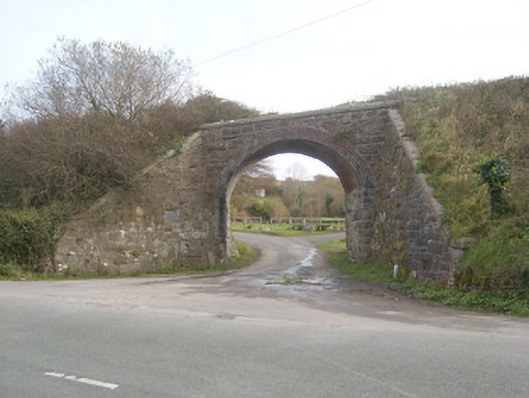
Bridge in Ardeelan Lower

Bridge
Bridge in Ardeelan Lower
Photo: National Inventory of Architectural Heritage · Report the wrong picture

This does not grant access. Most recorded buildings are privately owned; view them only from public ground unless the owner allows entry.

What do you know about this place?Tap to add a comment or ask a question

What you write will be public.

What is recorded here

Single-arch railway former railway bridge, built c. 1903-5, carrying former Donegal Town to Ballyshannon narrow gauge railway line over road. Railway lines now out of use with tracks removed (c. 1960). Squared rubble stone construction to spandrels, parapets, and with squared and mildly snecked abutments/retaining…

Read the whole record
Single-arch railway former railway bridge, built c. 1903-5, carrying former Donegal Town to Ballyshannon narrow gauge railway line over road. Railway lines now out of use with tracks removed (c. 1960). Squared rubble stone construction to spandrels, parapets, and with squared and mildly snecked abutments/retaining walls to embankments to either side. Cement coping over parapets and abutments. Squared rock-faced masonry to piers/below springing point having dressed margins. Segmental-headed arch having red brick voussoirs (four courses) and with obliquely-set/skewed red brick construction to arch barrel. Modern plaque dated 1997 to the abutment to the north-west. Deck now overgrown. Railway embankment runs away to either side (north-east and south-west). Located to the north of Ballyshannon and to the south-west of Ballintra. Sited a short distance to the south-west of Rossnowlagh Presbyterian church (see 40910314).
This former railway bridge retains much of its original form and character despite the closure of the line in 1960. It was restored in 1997 by a local amenity group and is an interesting feature in the rural landscape to the north of Ballyshannon. The red brick voussoirs and the skewed red brick construction to the arch barrel are interesting features of some technical merit. The use of red brick is not a typical feature of the railway bridges along this railway line. The use of good-quality mildly rock-faced masonry for the construction of the piers is a typical feature of late Victorian and Edwardian railway engineering and architecture in Ireland. It was originally built by the Donegal Railway Company as part of the Donegal Town to Ballyshannon narrow gauge railway line, which opened in September 1905 and closed completely on January 1st 1960. This railway bridge forms part of a group of structures associated with this former narrow gauge railway line in the Ballintra/Rossnowlagh area and is an integral element of the built heritage and transport history of County Donegal.

From the Buildings of Ireland (National Inventory of Architectural Heritage) record 40910301

Places near here

Picture notes
  • Kenneth Allen, Wikimedia Commons · CC BY-SA 2.0
  • National Inventory of Architectural Heritage
  • Computer-made picture. It does not show this monument.
  • Dean Molyneaux, Geograph · CC BY-SA 2.0
  • Computer-made picture. It does not show this mountain top.
  • louise price, Wikimedia Commons · CC BY-SA 2.0
  • Computer-made picture. It does not show this walking route.
  • Kay Atherton, Geograph · CC BY-SA 2.0
Rossnowlagh Presbyterian ChurchChurch/chapel · 107 yd

Explorer Tom Rossnowlagh Presbyterian Church is swapping its original timber cladding for modern corrugated steel, but that little bellcote spirelet keeps the charm alive. It’s a small-scale beauty in Ardeelan Lower that refuses to be boring! Give that spire a little nod, will you?

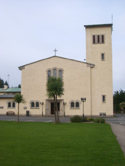
Rossnowlagh Franciscan Friary ChurchChurch/chapel, friary · 141 yd

Explorer Tom Rossnowlagh Franciscan Friary Church is serving up some quasi Lombardic-Romanesque style with its round-headed openings and stained glass. It’s got a campanile that looks straight out of Italy, but it’s actually in County Donegal. Tell me if you see any monks hiding inside!

Bullaun stone in Cool MoreBullaun stone · 377 ydComputer-made picture

Explorer Tom Bullaun stone in Cool More is just a name to me, but I bet it’s a giant’s little bathtub. Maybe it still smells like ancient soap and rain, waiting for someone brave enough to have a splash.

Fairy fort / earthen ringfort in Cool MoreFairy fort / earthen ringfort · 424 ydComputer-made picture

Explorer Tom Fairy fort / earthen ringfort in Cool More sits on a hilltop above Rossnowlagh Beach, but a modern fence cuts right through the middle. It’s a bit rude, really, splitting the circle in half. The bank is still there, though, so it’s holding its ground against the farm.

RossnowlaghOfficial bathing water · 1113 yd

Explorer Tom Rossnowlagh seems determined to be a whole journey rather than one beach. Donegal tourism runs it from Coolmore’s cliffs to Carrickfad’s rock. I would need a bigger postcard for that stretch of golden sand; the surfers have probably had that problem for years.

Cashel HillMountain / peak · 1236 ydComputer-made picture

Explorer Tom This third Cashel Hill is doing its best to be unique, but honestly, it's just another hill with a name tag. Go on a wet day, it suits the mood and saves you washing your boots.

Kilbarron Old Church GraveyardGraveyard · 1.4 mi

Explorer Tom Kilbarron Old Church Graveyard features a 15th or 16th century ruin with a 2.4m high E gable that has no window at all. That is quite the dramatic lighting choice for a place meant to let in some divine brightness.

Lurgan CoraMountain / peak · 1.9 miComputer-made picture

Explorer Tom Lurgan Cora is in a feud with the next village over who stole a specific hat. It’s been going on for decades. Best seen with a hangover and a sausage roll to soothe your soul after the chaos.

Dark Cliffs at KilbarronPublicly named cliff or headland · 2.0 mi

Explorer Tom Dark Cliffs at Kilbarron sound like a gothic novel title written by a depressed teenager. They’re brooding, moody, and probably judging your photography skills. Snap one photo, then put the phone away and actually look.

Kilbarron Castle in ruinsCastle, tower house · 2.0 mi

Explorer Tom Kilbarron Castle in ruins clings to a precipitous promontory, where the O'Clerys rebuilt their stronghold after 1390. I love that trace of an underground passage, though it’s blocked up now. It’s basically a cliff-edge mystery with some very stubborn stone footing.

Creevy Coastal WalkOfficial walking route · 2.4 miComputer-made picture

Explorer Tom Creevy Coastal Walk is a four-kilometre loop that would absolutely terrify any nosey neighbour trying to peek over the fence. The coastline guards its secrets better than a bank vault. Make up your own legend and I'll swear it's true.

Creevy Pier HotelHotel · 2.4 mi

Explorer Tom Creevy Pier Hotel suggests you're staying on a pier that might wobble dangerously in high tide, with the 'hotel' part doing heavy lifting. It’s basically a restaurant pretending to be accommodation, so don't trust the balcony too much. Bring your nan, she'll know more than me.

More historic places in County Donegal · All of County Donegal

Add to this placeAdd a picture Add a detailed tip Add a story

Explore the map1,093,392 places to discover

Next place · or swipeRossnowlagh Presbyterian Church