Places near here
Photo credits
- National Inventory of Architectural Heritage
- Kenneth Allen, Geograph · CC BY-SA 2.0
- Corinna Schleiffer, Wikimedia Commons · CC BY-SA 2.0
- Radosław Botev, Wikimedia Commons · CC BY 3.0 pl
- Wanfried-Dublin, Wikimedia Commons · CC BY-SA 4.0
- Kenneth Allen, Wikimedia Commons · CC BY-SA 2.0
- Attila Terbócs, Wikimedia Commons · CC BY-SA 3.0
- DAYVEHUSE, Wikimedia Commons · CC BY-SA 4.0
- James Emmans, Geograph · CC BY-SA 2.0
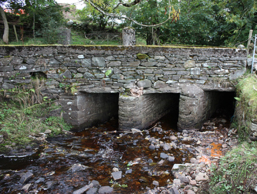
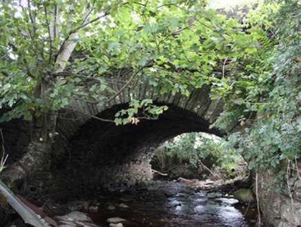 Ballintroohan BridgeBridge · 203 yd
Explorer Tom Ballintroohan Bridge has been taking the traffic since c. 1800, proving that simple masonry skills can stand the test of time. It’s a tidy little segmental arch that fits right into the rural setting. Not much fanfare here, but it’s done its job for over two centuries without a hitch.
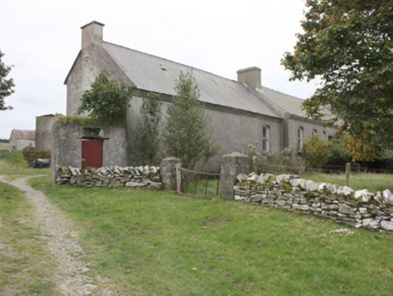 Grouse HallCountry house · 701 yd
Explorer Tom Grouse Hall is a 1735 gem that’s currently letting the weeds eat its elegance. It’s one of Donegal’s earliest demesne houses, with a walled garden and corbelled eaves that scream old money. Even in this derelict state, the early fabric still looks expensive, if you ignore the overgrown mess.
 Orchard BarPub · 1.1 mi
Explorer Tom Orchard Bar in County Donegal has an unlikely celebrity friend who only visits when the cider is fresh. I’d bet they keep a secret orchard just for their own private boozy harvest. Wave at the cows, they're the real locals.
 CrockavishaneMountain / peak · 2.2 mi
Explorer Tom Crockavishane in Donegal is having a very fancy lunch experience that costs nothing but your dignity. It’s all about the ambiance of doing absolutely nothing productive. Have a sandwich here and call it a heritage lunch.
 Stone CrossesCross, High cross · 2.7 mi
Explorer Tom On the other side of the road sits the *Stone Crosses* known as the South Cross, which is a real showstopper with its west face carved with Christ flanked by angels. It’s a 2.8m tall masterpiece from an early Christian enclosure, so try not to get too distracted by the fact that it’s standing right next to a modern school.
.jpg/250px-Knockergrana_(5).jpg "Photo: Wanfried-Dublin, Wikimedia Commons · CC BY-SA 4.0") Former site of Knockergrana Court TombCourt tomb · 2.8 mi
Former site of Knockergrana Court TombCourt tomb · 2.8 miExplorer Tom Former site of Knockergrana Court Tomb was blasted apart with dynamite in the early 1900s, leaving only a few slabs and boreholes as evidence. It’s a bit messy now, but if you look closely at those broken stones, you can almost feel the tenant’s frustration trying to clear it.
 CroaghmoreMountain / peak · 3.3 mi
Explorer Tom Croaghmore in County Donegal would win a county fair easily, simply by standing still and looking vaguely impressive while everything else tries too hard. It’s the kind of hill that wins prizes without even entering them, just by existing so grandly. Visit, then text me what you think. I'll pretend to read it.
 Cooley CrossMemorial · 4.1 mi
Explorer Tom Cooley Cross hosted a dance that went so wild that someone actually broke a fence, and they still blame the cross for it. The locals say the stone vibrated with the bass, which is either true or a very good story. Stand where the owner stood and practise looking smug.
 Cooly GraveyardGraveyard · 4.1 mi
Explorer Tom Cooly Graveyard held an unusual find during a cleanup in 2010: half a millstone near the east wall. The record says it may have served as a headstone; its original mill has not been located either. I love that one stone brings two questions here, but neither possibility is certain.
 McGrory'sHotel · 4.2 mi
Explorer Tom McGrory’s in Culdaff looks like it’s been standing there since the last glacial period on Malin Road. Check if the heating works before you commit to staying the night, trust me on this one. Give it a pat on the way past, it's had a long life.
 Tremone BayBeach / strand · 4.2 mi
Explorer Tom Tremone Bay has been keeping an icy secret in its rocks. Geological Survey Ireland records debris dropped by ancient ice in the bedrock at White Strand’s northwest end, roughly 590 to 570 million years old. I cannot blame the beach for looking smug; most places would brag about a history half that long.
 CuldaffOfficial bathing water · 4.6 mi
Explorer Tom Culdaff Beach looks as if three pieces of the map agreed to meet for tea: dunes to the west, two rock outcrops to the southeast, and the Culdaff River to the northwest. The sand has quite a supporting cast. This protected coast deserves a gentle visit.
More historic places in County Donegal · All of County Donegal

What do you know about this place?Tap to add a comment or ask a question