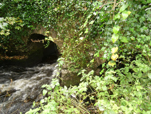
What is recorded here
Two-arch road bridge carrying small road over the Abbey River, built c. 1675. Two segmental-headed arches having roughly dressed and squared stone voussoirs. Rubble stone V-profile cutwater with corbelled head to central pier on upstream elevation (east). Rubble stone construction to spandrels, abutments, barrels and…
Read the whole record
From the Buildings of Ireland (National Inventory of Architectural Heritage) record 40852005
Places near here
Picture notes
- National Inventory of Architectural Heritage
- louise price, Geograph · CC BY-SA 2.0
- Computer-made picture. It does not show this monument.
- Computer-made picture. It does not show this playground.
- Kenneth Allen, Geograph · CC BY-SA 2.0
- Kenneth Allen, Wikimedia Commons · CC BY-SA 2.0
- Jonathan Wilkins, Geograph · CC BY-SA 2.0
- louise price, Wikimedia Commons · CC BY-SA 2.0
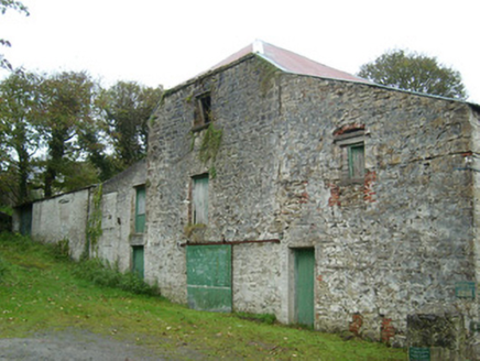 mill (water)43 yd
Explorer Tom Mill at Abbeylands has been churning out corn and flax since around 1800, with its waterwheels restored in 1989 for a heritage centre. It’s a fantastic spot to grab a coffee while watching the old machinery slowly turn in the river.
 CatsbyBuilding misc, mass rock · 100 yd
Explorer Tom Catsby hides a tiny stone altar that’s only half a metre wide! From 1695 to 1750, priests stood in that narrow cave while the river roared nearby. I wonder if anyone ever tried to hug the rock? It feels like the most cramped office desk I’ve ever seen.
 Bullaun stone in Abbey IslandBullaun stone · 109 ydComputer-made picture
Explorer Tom Bullaun stone in Abbey Island hides inside a cavern called 'Catsby', which makes me think a giant cat slept there and left its paw prints. I wonder if it still purrs when the wind blows through those little rock bowls?
 Architectural fragment in Abbey IslandArchitectural fragment · 154 ydComputer-made picture
Explorer Tom Architectural fragment in Abbey Island is basically a 12th-century jigsaw puzzle that monks dropped on purpose. The Cistercian abbey was plundered by Niall Óg O'Neill back in 1398, so these scattered capitals are just the broken bits of a very expensive renovation gone wrong.
 Children's playground681 ydComputer-made picture
Explorer Tom Children's playground in County Donegal has no map, which is exactly why it’s so charmingly confusing. Get lost on purpose, it’s cheaper than therapy and far more fun. Bring a map, get lost anyway, that's the fun.
 McGinley's BarPub · 786 yd
Explorer Tom McGinley's Bar in County Donegal was nearly sold for a horse, which is either amazing or terrifying depending on your view of value. Serious arguments happen over trivial pub trivia here, so keep your wits about you. Linger, it's not going anywhere and neither should you.
 St Anne's Church GraveyardGraveyard · 854 yd
Explorer Tom St Anne's Church Graveyard is where the real history of Ballyshannon sleeps, next to a church that moved in 1691 and got new bones in 1841. It’s serious business with a side of tradition. Great spot to propose. Or at least to propose lunch, keep it light.
 Shannon's CornerRestaurant · 869 yd
Explorer Tom Shannon's Corner restaurant in Donegal would bring a very unremarkable cake to a party because it’s terrified of being too interesting. It sits at the corner looking mysterious but mostly just confused. Dare you to say hello to it out loud.
 Rory GallagherMemorial · 1145 yd
Explorer Tom Rory Gallagher memorial? That's just a guy who played guitar, right? Well, sort of. Go back in winter, it's a different animal when the wind is howling and you're pretending you know what you're doing.
 Wardtown StrandBeach / strand · 1.5 mi
Explorer Tom Wardtown Strand has regular navigation marker-poles indicating the sinuous river channel. I reckon those poles are doing a lot of heavy lifting while the sand just sits there, wet and unbothered. It is a very organized mess.
 Tullan StrandBeach / strand · 1.9 mi
Explorer Tom Tullan Strand gets the Atlantic swell head-on along Bundoran's north side. Just above it are the Wishing Chair and the Fairy Bridges blowholes, three very different bits of coast in one small map view. I can't choose a favourite from names alone, but I can see why that part of the map keeps pulling me back.
 Dark Cliffs at KilbarronPublicly named cliff or headland · 2.6 mi
Explorer Tom Dark Cliffs at Kilbarron sound like a gothic novel title written by a depressed teenager. They’re brooding, moody, and probably judging your photography skills. Snap one photo, then put the phone away and actually look.
More historic places in County Donegal · All of County Donegal

What do you know about this place?Tap to add a comment or ask a question