Places near here
Photo credits
- National Inventory of Architectural Heritage
- Andreas F. Borchert, Wikimedia Commons · CC BY-SA 4.0
- kevin higgins, Geograph · CC BY-SA 2.0
- Mike Searle, Wikimedia Commons · CC BY-SA 2.0
- Richard Webb, Geograph · CC BY-SA 2.0
- kevin higgins, Wikimedia Commons · CC BY-SA 2.0
- Jonathan Thacker, Geograph · CC BY-SA 2.0
Explorer Tom Enclosure in Brideswell got moved to the wrong spot by a confused surveyor long ago. It looks like a square that gave up halfway through being round. Sit on a wall near it and pretend you're in a painting.
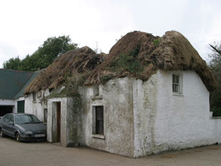 farm house889 yd
Explorer Tom Pollmanagh Little Farmhouse is the sort of place where you’d count every single cup of tea used to build the walls. It’s got a high-pitched roof covered in oat thatch and looks like it’s been through a bit of a mud bath. Gaze at its windbreak from afar and wonder what the daub says.
 Baldwinstown HouseFarm house · 1124 yd
 Font in BallyconnickFont · 2.2 mi
Explorer Tom Font in Ballyconnick is stuck in the ground without a drain hole, so it’s basically holding its breath. A cow once tried to buy it for a shiny coin, but the farmer said no. Make a wish, it's had centuries of practice.
Carrickatinna RockMountain / peak · 3.3 miExplorer Tom Carrickatinna Rock lost a bet with a priest back in the day and has been sulking about the odds ever since. The rock is still stiff from the argument, refusing to budge an inch just to prove a point. Ideal stop for a big stretch and a bigger yawn.
The Heron's MeadowForest · 4.0 miExplorer Tom The Heron’s Meadow has an imaginary twin across the sea that it calls every night to complain about the wind. It’s basically a gossip column for birds who don’t have anything better to do. Visit, then text me what you think. I'll pretend to read it.
1798 Memorial PlaqueMemorial · 4.2 miExplorer Tom The whole parish once argued about this 1798 Memorial Plaque until they all agreed to just leave it alone and pretend nothing happened. It’s still got that 'we’ll see' look on its face, so pop by and tell it it's looking well to settle the score. Pop by and tell it it's looking well.
 Cull IslandIsland · 4.2 mi
Explorer Tom Cull Island smells like wet wool and regret, according to my nose which I trust implicitly. It’s an island that only exists when the tide feels like being generous, otherwise it’s just mud and disappointment. Have a look and decide if I was lying.
_-_geograph.org.uk_-_3715787.jpg/250px-Castles_of_Leinster,_Ballyhealy,_Wexford_(1)_-_geograph.org.uk_-_3715787.jpg "Photo: Mike Searle, Wikimedia Commons · CC BY-SA 2.0") Castle (in ruins)Castle, tower house · 4.3 mi
Castle (in ruins)Castle, tower house · 4.3 miExplorer Tom Castle in Ballyhealy Castle claims it’s older than the Cheevers family, but really it’s just been standing there since the 13th century pretending it’s not tired. William Chevre signed a charter nearby, so maybe he built it while waiting for the ink to dry. Toast it with a cup of tea and move on to the next one.
 Forth MountainMountain / peak · 4.5 mi
Explorer Tom Forth Mountain is absolutely sick of being asked if it’s related to the River Forth in Scotland; it’s just a hill, not a geography lesson. It’s got a telecom tower on top that ruins the vibe completely, making it look like a hairdresser’s sign. Find the wonkiest bit and send it to your group chat.
 Ballyteigue BurrowNature reserve · 5.0 mi
Explorer Tom Ballyteigue Burrow is a nature reserve where the stones are whispering a hidden message that translates roughly to 'please stop stepping on my toes.' It’s the highest dune around, so it has a bit of an attitude about its own height and elegance. Dare you to say hello to it out loud.
 Taghmon CastleCastle · 6.0 mi
Explorer Tom Taghmon Castle swears it’s older than the first mention in 1548, which is a wild claim for a coastal spot! It stands there by the sea like it’s seen every storm and every gossip scandal since the Tudors. If it's closed, admire it from the road like a polite stalker.
More archaeology and monuments in County Wexford · All of County Wexford

What do you know about this place?Tap to add a comment or ask a question