
What is recorded here
Breascleit is a clearance cairn in Na h-Eileanan Siar, Scotland.
From the Historic Environment Scotland record 346347
The historic-place record does not grant public access. Check current conditions and ownership before entering land or a building.
Places near here
Photo credits
- James Allan, Wikimedia Commons · CC BY-SA 2.0
- Sandy Gerrard, Wikimedia Commons · CC BY-SA 2.0
- Robert Watson, Wikimedia Commons · CC BY-SA 2.0
- Eileen Henderson, Wikimedia Commons · CC BY-SA 2.0
- David Bremner, Wikimedia Commons · CC BY-SA 2.0
- Gordon Hatton, Wikimedia Commons · CC BY-SA 2.0
- Tom Richardson, Wikimedia Commons · CC BY-SA 2.0
- Bob Embleton, Wikimedia Commons · CC BY-SA 2.0
- Colin Smith, Wikimedia Commons · CC BY-SA 2.0
 Largest house in BreascleitOld home or work place · 176 yd
 Lewis, Breasclete, Lightkeepers Dwelling HousesLighthouse Shore Station (19th Century) · 190 yd
 Lewis, StonefieldStanding Stone (prehistoric) · 231 yd
 BreascleteBlackhouse (modern) · 281 yd
 Callanish CemeteryChurch, cross or graveyard · 946 yd
_War_Memorial_-_geograph.org.uk_-_7765514.jpg/250px-East_Loch_Roag_(Callanish,_Garynahine_and_Breasclete)_War_Memorial_-_geograph.org.uk_-_7765514.jpg "Photo: David Bremner, Wikimedia Commons · CC BY-SA 2.0") East Loch Roag War MemorialMemorial · 1396 yd
East Loch Roag War MemorialMemorial · 1396 yd CeabhaighIsland · 1759 yd
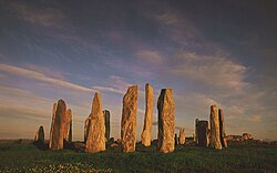 Tursachan ChalanaisHeritage attraction · 1.3 mi
 Bratanais MòrIsland · 1.5 mi
 Am Port MòrBay · 1.6 mi
 Port a' ChaoilHeadland · 1.7 mi
 Norse MillHeritage attraction · 3.2 mi
More archaeology and monuments in Na h-Eileanan Siar · All of Na h-Eileanan Siar
What do you know about this place?