
Places near here
Photo credits
- Andrew Smith, Wikimedia Commons · CC BY-SA 2.0
- Chris Newman, Wikimedia Commons · CC BY-SA 2.0
- Walter Baxter, Wikimedia Commons · CC BY-SA 2.0
- James Denham, Wikimedia Commons · CC BY-SA 2.0
- Colin Kinnear, Wikimedia Commons · CC BY-SA 2.0
- Richard Webb, Wikimedia Commons · CC BY-SA 2.0
- Billy McCrorie, Wikimedia Commons · CC BY-SA 2.0
 Glencorf BurnEnclosure, Lazy Beds (post Medieval) · 1013 yd
 Wauchope SchoolhouseSchoolhouse · 1227 yd
 Earshaw SikeFarmstead (medieval) - (post Medieval), Rig and Furrow (medieval) - (post Medieval) · 1282 yd
 Bigholms BurnEnclosure (possible) · 1333 yd
 Naze HillMountain / peak · 1.8 mi
 Craighope HeadMountain / peak · 2.0 mi
 War MemorialMemorial · 2.1 mi
 Langholm CemeteryCemetery · 2.1 mi
 The Buccleuch CentreHeritage attraction · 2.3 mi
 Gallowside WoodWood · 2.3 mi
 Welcome To LangholmVisitor information · 2.3 mi
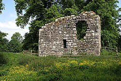 Langholm CastleTower House (16th Century) · 2.3 mi
More historic places in Dumfries and Galloway · All of Dumfries and Galloway

What do you know about this place?Tap to add a comment or ask a question