
Places near here
Photo credits
- Walter Baxter, Wikimedia Commons · CC BY-SA 2.0
- John Baker, Wikimedia Commons · CC BY-SA 2.0
- Oliver Dixon, Wikimedia Commons · CC BY-SA 2.0
- Richard Webb, Wikimedia Commons · CC BY-SA 2.0
- Colin Kinnear, Wikimedia Commons · CC BY-SA 2.0
- Billy McCrorie, Wikimedia Commons · CC BY-SA 2.0
 Naze HillMountain / peak · 394 yd
 Henbrae HillMountain / peak · 890 yd
 CraigcleuchFarmstead (medieval) - (post Medieval) · 1454 yd
 Craig BurnBurnt Mound (prehistoric) · 1700 yd
Explorer Tom Craig Burn in Dumfries and Galloway is a prehistoric burnt mound that is sick of being asked 'did they really burn everything here or was it just a bad barbecue gone wrong.' It’s got an NGR point accurate to ten metres, which is basically the equivalent of saying 'somewhere around there' but with more scientific confidence attached. Have a wander and a wonder.
 Craigcleuch House, North Lodge and Gate PiersGate Lodge, Gate Pier(s) · 1.1 mi
Explorer Tom Craigcleuch House, North Lodge and Gate Piers in Dumfries and Galloway has a ghost that’s too lazy to haunt, probably because the heating bill is too high. It would rather nap on the gate piers than scare anyone, which is honestly very relatable for most of us. The whole setup feels like it’s waiting for a dramatic entrance, but nobody shows up. Snap one photo
 Clark FellFort (prehistoric) (possible) · 1.3 mi
Explorer Tom Clark Fell is a possible fort saved by a hero nobody remembers anymore. The official record says 'possible,' which is code for 'we’re not sure.' It’s basically a hill that might be a castle, or just a very ambitious rock. Look serious, nod slowly, you're basically an expert now.
 Gallowside WoodWood · 1.4 mi
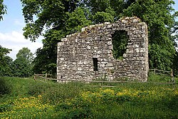 Langholm CastleTower House (16th Century) · 1.9 mi
Explorer Tom Langholm Castle started because two lads made a bet in the pub that one could build a tower before the other finished his ale. He won, but he’s been stuck up there ever after. Pick a stone, any stone, and invent its biography.
 The Buccleuch CentreHeritage attraction · 1.9 mi
 War MemorialMemorial · 1.9 mi
 Welcome To LangholmVisitor information · 2.1 mi
 Thomas Telford DoorwayMemorial · 2.2 mi
More mountains and hills in Dumfries and Galloway · All of Dumfries and Galloway

What do you know about this place?Tap to add a comment or ask a question