What is recorded here
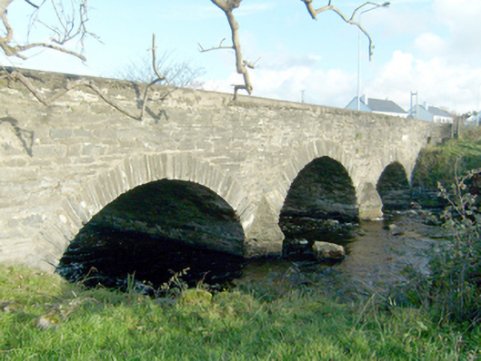
Triple-arch bridge crossing Abhainn Thulacha Beigile [Tullaghobegly River], built c.1800, having V-profile rubble stone cutwaters to piers to both upstream and downstream elevations (south and north). Segmental-headed arches having roughly dressed and squared rubble stone voussoirs; rubble stone construction to arch barrels. Rubble stone construction to piers, abutments, and spandrels. Rendered rubble stone parapets with chamfered coping over. Rendered rubble stone coping to cutwaters. Tarmacadam deck. Located in the rural countryside to the west of An Fál Carrach [Falcarragh] along the N56 road to An Clochán Liath [Dunglow].
This appealing and elegant triple-arched road bridge retains much its early character and form, and is an appealing feature in the rural landscape to the west of An Fál Carrach [Falcarragh]. It is robustly-constructed in local rubble stone masonry, and its continued survival and use stands as testament to the quality of its original construction, and of the skill of the masons involved. The rubble stone construction creates rather a picturesque and rustic appearance, while the three graceful arches and rubble stone cutwaters add to its appeal. This bridge probably dates to the end of the eighteenth century or the first decades of the nineteenth century, a period that saw a great deal of road and bridge-building in Ireland, particularly by the Grand Juries (the forerunners of the County Councils). This appealing bridge is an integral element of the built heritage and transport heritage of the local area, and makes a positive contribution to the local landscape.
This does not grant access. Most recorded buildings are privately owned; view them only from public ground unless the owner allows entry.
Places near here
 Castle Bawne (in Ruins)Bawn · 283 yd
 Saint Ann's Church (Killult)church/chapel · 487 yd
 Ardnadrean Rectoryrectory/glebe/vicarage/curate's house · 783 yd
 Enclosure in An Cheathrú CheanainnEnclosure · 1413 yd
 Cashelmacadowan FortFairy fort / stone ringfort · 1677 yd
 Monterey CypressMonterey Cypress · 1.1 mi
 Wych ElmWych Elm · 1.1 mi
 Trá Dhroim na TineBeach / strand · 1.8 mi
 DrumnatinnyOfficial bathing water · 2.2 mi
 Inis Bó FinneIsland · 3.7 mi
 Oileán DúicheIslet · 4.3 mi
 Mc Swyne's GunHeritage attraction · 5.3 mi
Other information
Photo: National Inventory of Architectural Heritage · Website use allowed for educational or private purposes with source credit