Places near here
Photo credits
- Kenneth Allen, Geograph · CC BY-SA 2.0
- Kenneth Allen, Wikimedia Commons · CC BY-SA 2.0
- Colin Park, Geograph · CC BY-SA 2.0
- David Trochos at English Wikipedia, Wikimedia Commons · Public domain
- Rossographer, Geograph · CC BY-SA 2.0
- Colin Park, Wikimedia Commons · CC BY-SA 2.0
 Swann's BridgePicnic place · 762 yd
Explorer Tom Swann's Bridge is off Seacoast Road and if it won the lotto, it’d probably buy a very expensive pair of wellingtons for every seagull that ever pooped on it. It’s a picnic place that feels like it’s judging your sandwich choices while you pretend not to notice the view. Bring your own legend, I've run out.
 Bellarena SchoolSchool · 864 yd
Explorer Tom Bellarena School in Bellerena is where they taught kids how to survive boredom before smartphones existed. The least favourite visitor was definitely the headmaster’s uncle, probably. Look up, the best bit is always higher than you think.
 Aidan's WellSpring · 1.3 mi
Explorer Tom Aidan's Well started because two lads bet in a pub that water would come from nowhere. They lost badly, but the well kept flowing to prove them right. Sit on a wall near it and pretend you're in a painting.
 Binevenagh ViewViewpoint · 1.6 mi
Explorer Tom Binevenagh View in County Derry was once ruled by a goat who demanded tribute in exchange for good weather. It’s a spot where you can see Windy Hill looking particularly wind-blown, which is its whole brand really. If it rains, blame me.
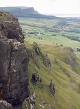 BinevenaghMountain / peak · 1.7 mi
Explorer Tom Binevenagh rises over the north coast like a cliff that decided to become a whole hill. The old lava country of the Antrim Plateau ends here, shaped by eruptions roughly sixty million years ago. Below are the Magilligan Peninsula and Benone Beach; above, gliders use the slopes because even the wind fancies the view. Bishop's Road crosses the high ground and has a lookout toward Lough Foyle and Inishowen. I would offer to fly you there myself, but I am much better at describing a landing than making one. Use the recognised viewpoint or permitted walking routes, check conditions and keep well back from cliff edges. The protected landscape has more to show than the first panorama, so allow time for the change from grassy high ground to sudden drop. If the sky is clear, Donegal may wave back across the water.
 Aghanloo Church of Ireland ChurchChurch · 1.8 mi
Explorer Tom Aghanloo's Church of Ireland was built in the 1820s and once a cow tried to buy it with a carrot. It's now just a church, but with drama. Stand still and listen, the wind tells it better than me and probably judges you less.
 North Base Station, Lough Foyle Base LineMonument · 2.8 mi
Explorer Tom North Base Station, Lough Foyle Base Line in County Derry would explain the 1800s to a teenager by showing them a very boring map. It’s been sitting there since 1827 measuring things with a precision that just makes my head spin a little bit. It’s a monument to being exactly where you’re supposed to be, every single day. Bring wellies and low expectations, leave delighted.
 Ballyhanna ForestForest · 3.7 mi
Explorer Tom The local sheep at Ballyhanna Forest think this place is overrated because they’ve been eating the same grass there for decades. They’re not wrong, of course, but they’d probably charge you an arm and a leg just to confirm that fact for you personally. Go before the tourists find out.
 Where Jane Ross recorded Danny BoyMemorial · 4.1 mi
Explorer Tom Where Jane Ross recorded Danny Boy ended up here by pure accident, probably because she got lost in 1879. The sign is very serious about it, but I suspect the tune was just a draft. Bring a notebook and write the bit I made up.
 Manannán mac LirSculpture · 4.2 mi
Explorer Tom Manannán mac Lir sculpture in County Derry was probably built by a guy who was just trying to impress his girlfriend with some Celtic trivia. He looks like he’s about to catch a fish but has forgotten how to use his arms properly. Bring a flask of something warm and a story to swap.
 DrenaghCastle · 4.2 mi
Explorer Tom Drenagh would explain the 1800s to a teenager by saying, 'It was all very dramatic, like a group chat but with letters.' It probably had more gossip back then than your phone has now. Go with someone who loves old stuff and watch them melt into a puddle of historical enthusiasm.
 Rough FortArchaeological place · 4.3 mi
Explorer Tom The builder of Rough Fort was definitely thinking 'eh, close enough' while he laid those initial stones. It looks like a dog chewed it and then spat it back out in anger. Go on, count the windows and get it wrong like I did.
More castles and forts in County Derry · All of County Derry

What do you know about this place?Tap to add a comment or ask a question