
What is recorded here
Beinn an t-Seilich is a mountain or peak in Argyll and Bute, Scotland.
From OpenStreetMap (© OpenStreetMap contributors) n539750459
This does not grant access. Check current paths, opening conditions and ownership before entering.
Places near here
 Stob an EasMountain / peak · 1669 yd
 Gleann MorTownship · 1.0 mi
 Beinn an LochainMountain / peak · 1.1 mi
 Glen KinglasBothy (20th Century) · 1.2 mi
 Moses wellSpring · 1.8 mi
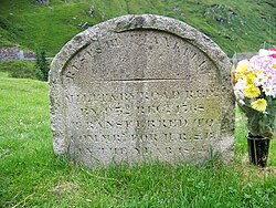 Rest And Be Thankful Memorial StoneMemorial · 1.9 mi
 Rest And Be ThankfulViewpoint · 1.9 mi
 Mightiest Conifer in EuropeSilver Fir · 2.0 mi
 ButterbridgeEnclosure · 2.0 mi
 High Glen CroeEnclosure(s), Farmstead, Kiln · 2.1 mi
 Easain DuibhWaterfall · 2.2 mi
 Cairndow War MemorialMemorial · 2.3 mi
Pictures: Iain Russell, Wikimedia Commons · CC BY-SA 2.0; Richard Webb, Wikimedia Commons · CC BY-SA 2.0; Trevor Littlewood, Wikimedia Commons · CC BY-SA 2.0; Steven Brown, Wikimedia Commons · CC BY-SA 2.0; Elliott Simpson, Wikimedia Commons · CC BY-SA 2.0; Robert Murray, Wikimedia Commons · CC BY-SA 2.0; Steve & Jemma Copley on Flickr, Wikimedia Commons · CC BY-SA 2.0; Iain Lees, Wikimedia Commons · CC BY-SA 2.0; Russel Wills, Wikimedia Commons · CC BY-SA 2.0; william craig, Wikimedia Commons · CC BY-SA 2.0
More mountains and hills in Argyll and Bute · All of Argyll and Bute
What do you know about this place?