What is recorded here
On undulating pasture 140m SW of the townland boundary with Stonepark. The ring-barrow (LI023-268----) is one of a pair of ring-barrows (LI023-292----) 8m apart. Ring-barrow (LI023-269----) located in the adjacent field 120m to ESE. The site is not depicted on historic OSi maps but is visible on OSi orthoimage taken 2005-12. Identified by Bruff aerial photographic survey in 1986 (Bruff 24901; AP 4/3706) as a circular ring-barrow (ext. diam. c. 10m). The ring-barrow is visible on Google Earth orthoimage taken 02/06/2018, it is less obvious on the most recent Google Earth orthoimage taken 28/06/2018. See attached Bruff survey image showing the site labelled Bruff 24901 and Google Earth orthoimages
Compiled by: Edmond O’Donovan
Date of upload: 4 September 2020
On undulating pasture 140m SW of the townland boundary with Stonepark. The ring-barrow (LI023-268----) is one of a pair of ring-barrows (LI023-292----) 8m apart. Ring-barrow (LI023-269----) located in the adjacent field 120m to ESE. The site is not depicted on historic OSi maps but is visible on OSi orthoimage taken 2005-12. Identified by Bruff aerial photographic survey in 1986 (Bruff 24901; AP 4/3706) as a…
From the National Monuments Service (Archaeological Survey of Ireland) record LI023-268
The monument record does not grant public access. Check the route and ask the landowner before entering private land.
- What survives
- Recorded monument
Places near here
Photo credits
- Mike Searle, Wikimedia Commons · CC BY-SA 2.0
- National Inventory of Architectural Heritage
- Mike Searle, Geograph · CC BY-SA 2.0
- Ronnie Nijboer, Wikimedia Commons · CC0
- Ruhrfisch, Wikimedia Commons · CC BY-SA 4.0
- Ballyhoura Failte, Wikimedia Commons · CC BY-SA 2.0
- Willow, Wikimedia Commons · CC BY 2.5
- JohnArmagh, Wikimedia Commons · Public domain
Enclosure in RochestownEnclosure · 435 yd Rockstown Castle (in ruins)Castle, tower house · 1025 ydWilliamstown CastleCastle/fortified house · 1226 ydRockstown ChurchMausoleum · 1296 ydBallynagarde HouseCastle, tower house · 1384 ydToberauillinSpring · 1.0 miSkool HillMountain / peak · 1.4 miWych Elm1.9 miGrange Stone CircleArchaeological place · 4.2 miGiants GraveMegalithic tomb · 4.7 miEuropean ash5.5 miMonasteranenagh AbbeyHeritage attraction · 6.1 mi
 Rockstown Castle (in ruins)Castle, tower house · 1025 yd
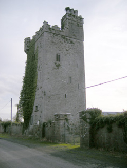 Williamstown CastleCastle/fortified house · 1226 yd
 Rockstown ChurchMausoleum · 1296 yd
 Ballynagarde HouseCastle, tower house · 1384 ydToberauillinSpring · 1.0 miSkool HillMountain / peak · 1.4 mi
 Wych Elm1.9 mi
 Grange Stone CircleArchaeological place · 4.2 mi
 Giants GraveMegalithic tomb · 4.7 mi
 European ash5.5 mi
 Monasteranenagh AbbeyHeritage attraction · 6.1 mi
More archaeology and monuments in County Limerick · All of County Limerick
What do you know about this place?