
Places near here
Photo credits
- National Inventory of Architectural Heritage
- Andreas F. Borchert, Wikimedia Commons · CC BY-SA 4.0
- Arnold Price, Wikimedia Commons · CC BY-SA 2.0
- David Dixon, Wikimedia Commons · CC BY-SA 2.0
- David Dixon, Geograph · CC BY-SA 2.0
- Kenneth Allen, Geograph Ireland via Wikimedia Commons
- Dr Neil Clifton, Wikimedia Commons · CC BY-SA 2.0
- N Chadwick, Wikimedia Commons · CC BY-SA 2.0
- N Chadwick, Geograph · CC BY-SA 2.0
- Dr Neil Clifton, Geograph · CC BY-SA 2.0
 Inishtrahull Lighthouse (old)Lighthouse, lighthouse keeper's house · 13 mi
Explorer Tom Inishtrahull Lighthouse in County Donegal is part of a feud between two families over who owns the best view of the sea from their windowsills. The keeper’s house is still there, waiting for someone to come home from a fishing trip that took too long. Climb up close and tell the light that you appreciate its constant, unblinking stare at the water.
 InishtrahullIsland · 13 mi
Explorer Tom You thought Malin Head was Ireland's topmost bit? Inishtrahull sits about ten kilometres farther out, and Tor Beg rock sneaks another little distance north. I would claim the map ends here, but Scotland would object. The island's gneiss is roughly 1.7 billion years old, making my oldest walking boots look embarrassingly new. People lived here until 1929, while lighthouse keepers stayed on duty until 1987. Now seabirds and visiting winter geese are among the most conspicuous residents. The island is protected and uninhabited; do not assume a boat sighting gives you permission to land. Arrange any visit through proper access and give nesting ground space, or admire it from a lawful sea trip. I will point out the lighthouse, then let the rock itself take over the story. It has had a very long time to prepare.
 Inishtrahull LighthouseLighthouse · 13 mi
Explorer Tom Inishtrahull Lighthouse on Inishtrahill is bragging about surviving a storm that could’ve flattened a small town. It claims the waves were so angry they forgot how to wave back at the ships. It’s the northernmost lighthouse, which means it’s basically the head of the class. Don’t ask it for directions; it likes being mysterious.
 Eire 80 signSecond World War neutrality sign · 17 mi
Explorer Tom EIRE 80 sign was written for eyes in the sky, not for someone standing beside it. The stones told wartime pilots they were over neutral Ireland, and 80 named Malin Head's lookout post. I would take the ground view slowly; this lettering had a much larger audience than most signs.
 Wild Atlantic Way:Malin HeadVisitor information · 18 mi
Explorer Tom Wild Atlantic Way:Malin Head in County Donegal is sick of being asked if it’s really the edge of the world, because yes, it is, stop asking already. The wind here is rude, the sea is loud, and the headland just wants to be left alone to contemplate its own northerly superiority in peace. Tell the next person you meet it's haunted. It might be.
 Malin HeadVisitor attraction · 18 mi
Explorer Tom Malin Head in County Donegal is where a fox took charge of the lighthouse and started collecting tolls from anyone who wanted to see the sunrise, which was very cheeky of him. It’s the tip of Ireland, so it feels like you’re standing on the edge of the world, except for the bit where there’s a shop selling overpriced souvenirs. The gulls are aggressive here
 Malin TowerSignal tower · 18 mi
Explorer Tom Behold Malin Tower, a square-plan structure that has served as everything from a signal station to a radio hub! It stands proudly on a rocky outcrop near Malin Head, offering some absolutely unobstructed views of the Atlantic.
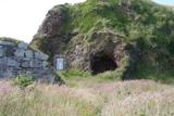 Wee House of Malin CaveCave · 18 mi
Explorer Tom Wee House of Malin Cave is measured at only 2.75 metres deep, yet the local saying gives it room for everything that goes in. That is one ambitious little house. The recorded cave sits beside Malin Well and the old church; I would let the story stretch the walls while leaving the real rock alone.
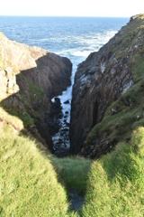 Hell's Hole Cavern, Malin HeadSea cavern and cliff chasm · 18 mi
Explorer Tom Hell's Hole Cavern, Malin Head is a long, narrow chasm that sounds like a drum kit being dropped off a cliff. The Atlantic tide rushes in with such a thunderous roar you can hear the water before you see it.

 Seaview TavernRestaurant · 18 mi
Explorer Tom At Seaview Tavern, the seafood is the star: crab, oysters and fish of all kinds up at Malin Head. Tom's only problem is choosing what to eat first. He may have to come back for round two.
 SkildrenbegIslet · 18 mi
Explorer Tom Skildrenbeg is the place where the seagulls hold their weekly council to decide who gets to steal the chip from your hand. They are extremely serious about it, and frankly, they are much more organized than most local governments. It's the kind of place that makes a dull Tuesday interesting.
 White StrandGuesthouse · 19 mi
Explorer Tom White Strand is probably white because it hasn't been cleaned since 1954, or maybe it’s just naturally that pristine. The guesthouse beds are likely made with feathers that belong to very angry geese who demand respect in return. Bring a map, get lost anyway, that's the fun.
More archaeology and monuments in Argyll and Bute · All of Argyll and Bute

What do you know about this place?Tap to add a comment or ask a question