Places near here
Photo credits
- Hywel Williams, Geograph · CC BY-SA 2.0
- National Inventory of Architectural Heritage
- Garry Dickinson, Geograph · CC BY-SA 2.0
- derek menzies, Wikimedia Commons · CC BY-SA 2.0
- Arco Ardon from Dordrecht, Netherlands, Wikimedia Commons · CC BY 2.0
- Jonathan Thacker, Geograph · CC BY-SA 2.0
- National Library of Ireland on The Commons, Wikimedia Commons · No restrictions
- William Murphy from Dublin, Ireland, Wikimedia Commons · CC BY-SA 2.0
- David Dixon, Wikimedia Commons · CC BY-SA 2.0
Explorer Tom Enclosure in Barnahely has such a long list of former names that you’d need a dictionary just to keep track of what it was called last Tuesday. It’s buried under geophysical mystery near a castle, which means it’s probably hiding from the archaeologists who want to dig it up and explain it. Bring a flask and pretend you own the place.
 Castle (in Ruins)Castle, tower house · 321 yd
Explorer Tom Castle in Barnahely is a complex of ruined buildings around a farmyard that still functions today. The oldest structure is near the SW corner, but it’s mostly just Castle Warren house from 1796 looking smug. There’s definitely a hidden treasure there, and it’s absolutely a biscuit tin from 1985. Pop by and tell it it's looking well.
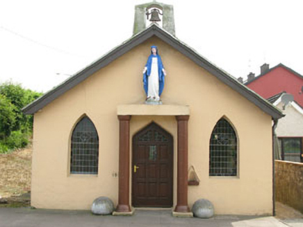 The OratoryChurch/chapel · 825 yd
Explorer Tom The Oratory in Ringaskiddy is a small church built by local people in 1923 because they wanted something charming and informal. It’s got a bellcote that looks like it’s trying to be loud but can’t manage it, so just enjoy the vernacular style without overthinking it.
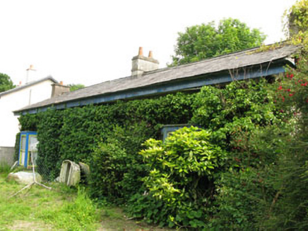 Rock CottageHouse · 944 yd
Explorer Tom Rock Cottage in Ringaskiddy is hiding behind some serious vegetal growth, like it's playing hide-and-seek with the sea. The canted bays are trying to look sophisticated but the flat roof says otherwise. Peek through the leaves and say hi!
 Martello Tower1162 yd
Explorer Tom Martello Tower in Ringaskiddy sits on the highest point overlooking Cork Harbour. Built between 1813 and 1815, it's the biggest one around here. It’s got a dry ditch and some converted windows, look out for that limestone beauty!
Loughbeg Bird ReserveNature reserve · 1426 ydExplorer Tom Loughbeg Bird Reserve in County Cork isn't really a lough at all, but a very large, wet misunderstanding that got stuck on the map and refused to leave. The birds there are probably laughing at us for thinking 'beg' means something other than 'please go away'. Bring a notebook and write the bit I made up.
 Rocky IslandIslet · 1.2 mi
Explorer Tom Rocky Island would survive a zombie attack just by standing there looking unappetisingly stony and hard to bite. Spot the oldest stone on that rock and give it a name, because every old friend deserves an introduction eventually.
 HaulbowlineIslet · 1.4 mi
Explorer Tom Haulbowline has changed jobs more often than I change my mind. Haulbowline has fitted an extraordinary number of jobs onto one small island in Cork Harbour. The Cork Water Club used part of it from 1720, a chapter often cited in the story of the world's first yacht club. Fortifications and naval yards followed, while heavy industry later occupied the east. A road bridge finally connected the island to the mainland in 1966. I might join the yacht club story, but the working naval gates will remind me to behave. Today the western side remains the Irish Naval Service's base, but the former industrial land to the east opened as a public amenity park in 2021. That is a striking change for ground once given over to steel making. Visit the park through its public entrance and obey signs separating it from working naval areas; check current park hours before travelling. Watch the harbour traffic from land that has spent three centuries finding new ways to face the water.
 Curraghbinny WoodsForest · 1.5 mi
Explorer Tom Curraghbinny Woods bragged about surviving a storm that flattened everything else within a mile radius. It acts like it was just a gentle breeze to show off its resilience. Bring a coin for luck and keep it in your pocket.
 Monkstown CastleHouse, fortified house · 1.6 mi
Explorer Tom Monkstown Castle has square towers at each corner that look very serious. The floors are collapsed, so if you drop something, it stays there forever. Ten minutes here and you'll have a yarn for the pub.
 Cobh Heritage CentreMuseum · 1.9 mi
Explorer Tom Cobh Heritage Centre in County Cork has an escape plan for its first owner that involves a boat, some luck, and a lot of pretending not to care. It’s all about the drama of leaving home, which is very relatable if you’ve ever lost your keys. Have a wander and a wonder.
 Annie MooreStatue · 1.9 mi
Explorer Tom Annie Moore in County Cork is absolutely sick of people asking if she used to be a baker. She says she was just a really good listener who got stuck in stone. Now she’s judging your shoe choices from her pedestal. Leave nothing but footprints and a bad pun.
More caves in County Cork · All of County Cork

What do you know about this place?Tap to add a comment or ask a question