DDiscover AloneMapAbout

Ballybulgan Bridge

Bridge
Ballybulgan Bridge
Photo: National Inventory of Architectural Heritage · Report the wrong picture

This does not grant access. Most recorded buildings are privately owned; view them only from public ground unless the owner allows entry.

What do you know about this place?Tap to add a comment or ask a question

What you write will be public.

What is recorded here

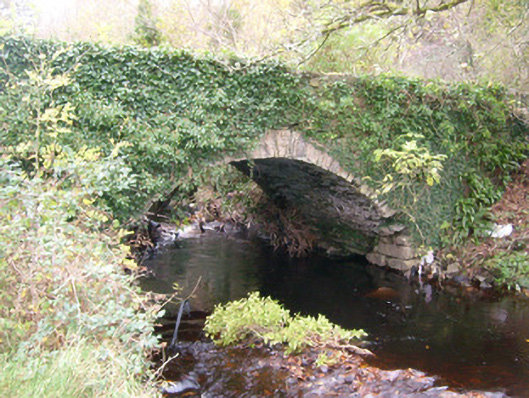
Single-arch bridge carrying road over the Ballintra River, built c. 1820. Segmental-headed arch having roughly dressed voussoirs to arch; rubble stone construction to arch barrel. Uncoursed rubble stone construction to spandrels; rubble stone construction to parapets having rubble stone coping over. Modern repairs in…

Read the whole record
Single-arch bridge carrying road over the Ballintra River, built c. 1820. Segmental-headed arch having roughly dressed voussoirs to arch; rubble stone construction to arch barrel. Uncoursed rubble stone construction to spandrels; rubble stone construction to parapets having rubble stone coping over. Modern repairs in places. Side elevations (east and west) now overgrown with ivy. Tarmacadam deck with grass verges. Located in the rural countryside to the north-west of Ballintra, adjacent to the west of former flax mill, now ruinous.
This picturesque rustic bridge retains much of its early character, and is an appealing feature in the rural landscape to the north-west of Ballintra. It is robustly-constructed in local rubble stone masonry, and its continued survival and use stands as testament to the quality of its original construction, and of the skill of the masons involved. This bridge is distinguished by the good-quality dressed voussoirs to the arch, and by the graceful wide single arch, which is a feature of some technical and engineering merit. This bridge probably originally dates to the early-nineteenth century, a period that saw a great deal of road and bridge-building throughout Ireland, particularly by the Grand Juries (the forerunners of the County Councils). This bridge is an integral element of the built heritage of the local area, and forms part of the extensive transport heritage of Donegal.

From the Buildings of Ireland (National Inventory of Architectural Heritage) record 40909925

Places near here

Picture notes
  • National Inventory of Architectural Heritage
  • Computer-made picture. It does not show this monument.
  • Computer-made picture. It does not show this mountain top.
  • Kenneth Allen, Geograph · CC BY-SA 2.0
  • Didier Descouens, Wikimedia Commons · CC BY-SA 4.0
  • Ian S, Geograph · CC BY-SA 2.0
  • N Chadwick, Geograph · CC BY-SA 2.0
  • Benson Wills, Wikimedia Commons · CC BY-SA 2.0
  • Dean Molyneaux, Geograph · CC BY-SA 2.0
Ballybulgan HouseHouse · 271 yd

Explorer Tom Ballybulgan House kept its slate roof and six-over-six sash windows when surveyors recorded it. Built around 1860, it stands back from the road. I picture it politely tipping its slate hat to the fields, as if being a farmhouse required good manners.

The Mill HouseMill manager's house · 516 yd

Explorer Tom The Mill House in Urbalshinny has a canted bay window staring right back at you. It’s got opinions on architecture, and it’s not shy about it. Bring the dog, it'll have even more opinions.

Fairy fort / earthen ringfort in Rathtinny GlebeFairy fort / earthen ringfort · 1003 ydComputer-made picture

Explorer Tom Fairy fort / earthen ringfort in Rathtinny Glebe is a large circular site with an internal diameter of roughly 38m, featuring a substantial bank and deep fosse. A modern field fence cuts straight through the interior, while the northern half remains overgrown and the southern half has trees growing on the bank. It’s perched on the east end of a ridge, offering good views despite the marshy valleys below.

Moneymore Fairy FortFairy fort / earthen ringfort · 1583 ydComputer-made picture

Explorer Tom Moneymore Fairy Fort sits on the crest of Horse Hill with gaps to the east and west. The earthen bank, likely scraped from the slope, is now planted with trees. It’s a thirteen-metre mystery commanding good views.

Buneeny HillMountain / peak · 1.5 miComputer-made picture

Explorer Tom Buneeny Hill is just sitting there, recorded merely as a mountain or peak in County Donegal. I suspect it has been waiting decades for someone to actually notice its specific personality rather than filing it under 'generic hill'.

CarrickMountain / peak · 1.5 miComputer-made picture

Explorer Tom Carrick is just listed as a standard mountain, yet its name means 'the rock' for a village that actually produced Mary Cunningham, the model for the $20 double eagle. I suspect the peak itself is still trying to figure out if it’s made of stone or gold.

MurvaghOfficial bathing water · 1.9 mi

Explorer Tom Murvagh Beach has a wartime lookout hut that Joy Browne, writing for Donegal tourism, remembers playing in as a child. She says erosion has since sunk it into the sand and made entry impossible. A lookout hut retiring by burying its feet is theatrical enough for me; I would leave it to its rest.

Hawthorn3.8 mi

Explorer Tom Hawthorn in County Donegal is having a bit of a tantrum about needing permission to be seen. I'm told it's fancy stuff, but honestly, just hugging it might scare the locals off. Give it a wink for me.

The HarbourRestaurant · 4.2 mi

Explorer Tom The Harbour restaurant on Quay Street would describe itself to a stranger as 'slightly damp but deliciously positioned' right where the boats bob along. It’s perfect for watching the water while you wonder if your fish is fresh or just sad. A good place to forget your phone for ten minutes.

Salthill CabinCafé · 4.2 mi

Explorer Tom Salthill Cabin near Mountcharles is likely just a shed with a coffee machine and serious delusions of grandeur. It’s in Donegal, so expect rain to pour straight through the roof. Bring your worst joke, the place has heard worse.

Donegal CastleCastle, tower house · 4.3 mi

Explorer Tom Donegal Castle is a massive tower house that survived being burned, demolished, and converted into a Jacobean manor. You can still see the carved Brooke fireplace with its intricate strapwork and armorial coats of arms inside. It’s a proper architectural time capsule where history got very messy.

RossnowlaghOfficial bathing water · 4.5 mi

Explorer Tom Rossnowlagh seems determined to be a whole journey rather than one beach. Donegal tourism runs it from Coolmore’s cliffs to Carrickfad’s rock. I would need a bigger postcard for that stretch of golden sand; the surfers have probably had that problem for years.

More historic places in County Donegal · All of County Donegal

Add to this placeAdd a picture Add a detailed tip Add a story

Explore the map1,093,392 places to discover

Next place · or swipeBallybulgan House