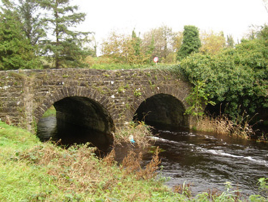
What is recorded here
Triple-arch road bridge, built c. 1780, carrying road over the Ballintra River. Possibly containing earlier fabric. Segmental-headed arches having dressed stone voussoirs and squared rubble stone construction to the arch barrels. Squared dressed stone V-profile cutwaters to piers to east/south-east elevation…
Read the whole record
From the Buildings of Ireland (National Inventory of Architectural Heritage) record 40849018
Places near here
Picture notes
- National Inventory of Architectural Heritage
- Computer-made picture. It does not show this mountain top.
- Computer-made picture. It does not show this monument.
- Kenneth Allen, Geograph · CC BY-SA 2.0
- Didier Descouens, Wikimedia Commons · CC BY-SA 4.0
- Dean Molyneaux, Geograph · CC BY-SA 2.0
- N Chadwick, Geograph · CC BY-SA 2.0
- louise price, Wikimedia Commons · CC BY-SA 2.0
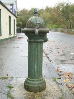 water pump38 yd
Explorer Tom Water pump in Ballintra wears an acorn on top, yet its original lever has gone and a modern tap has taken its place. The foundry mark points all the way to Kilmarnock in Scotland. A little acorn with a surprisingly long journey.
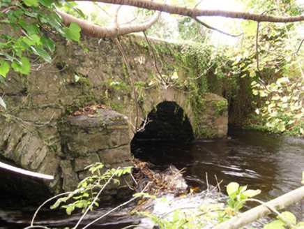 bridge189 yd
Explorer Tom Bridge in Ballintra wears sharp V-profile cutwaters on its piers that look like grumpy eyebrows. I picture them in c.1790 narrowing their stone eyes, daring the Ballintra River to splash higher than they expected. Do those rough-hewn brows ever blink?
 Buneeny HillMountain / peak · 695 ydComputer-made picture
Explorer Tom Buneeny Hill is just sitting there, recorded merely as a mountain or peak in County Donegal. I suspect it has been waiting decades for someone to actually notice its specific personality rather than filing it under 'generic hill'.
 Ballymagrorty Scotch Children's Burial GroundChildren's burial ground · 765 ydComputer-made picture
Explorer Tom Ballymagrorty Scotch Children's Burial Ground sits on a drumlin with a holy well at its base. It’s just a low mound now, but it was once an early church site. I’d bet the wind carries whispers of Rath Cunga down from that high spot.
 Ballymagrorty Scotch Ecclesiastical MoundMound · 765 ydComputer-made picture
Explorer Tom Ballymagrorty Scotch Ecclesiastical Mound is a low rectangular bump sitting proudly on top of a drumlin. It used to be the site of Rath Cunga, which sounds fancy until you realise it’s basically just dirt now. I’d bet the holy well at the base still hums with ancient secrets while the mound just naps.
 Dromore HillMountain / peak · 1.1 miComputer-made picture
Explorer Tom Dromore Hill sits in County Donegal with access details that remain completely unknown to the mapmakers. The name sounds like it is politely asking for a shortcut, but the landscape just offers a silent shrug. I imagine it standing there, waiting for someone to guess their way up while pretending they know exactly where they are going.
 MurvaghOfficial bathing water · 2.5 mi
Explorer Tom Murvagh Beach has a wartime lookout hut that Joy Browne, writing for Donegal tourism, remembers playing in as a child. She says erosion has since sunk it into the sand and made entry impossible. A lookout hut retiring by burying its feet is theatrical enough for me; I would leave it to its rest.
 Hawthorn2.7 mi
Explorer Tom Hawthorn in County Donegal is having a bit of a tantrum about needing permission to be seen. I'm told it's fancy stuff, but honestly, just hugging it might scare the locals off. Give it a wink for me.
 RossnowlaghOfficial bathing water · 3.8 mi
Explorer Tom Rossnowlagh seems determined to be a whole journey rather than one beach. Donegal tourism runs it from Coolmore’s cliffs to Carrickfad’s rock. I would need a bigger postcard for that stretch of golden sand; the surfers have probably had that problem for years.
 Salthill CabinCafé · 4.9 mi
Explorer Tom Salthill Cabin near Mountcharles is likely just a shed with a coffee machine and serious delusions of grandeur. It’s in Donegal, so expect rain to pour straight through the roof. Bring your worst joke, the place has heard worse.
 Kilbarron Old Church GraveyardGraveyard · 5.1 mi
Explorer Tom Kilbarron Old Church Graveyard features a 15th or 16th century ruin with a 2.4m high E gable that has no window at all. That is quite the dramatic lighting choice for a place meant to let in some divine brightness.
 Dark Cliffs at KilbarronPublicly named cliff or headland · 5.6 mi
Explorer Tom Dark Cliffs at Kilbarron sound like a gothic novel title written by a depressed teenager. They’re brooding, moody, and probably judging your photography skills. Snap one photo, then put the phone away and actually look.
More historic places in County Donegal · All of County Donegal

What do you know about this place?Tap to add a comment or ask a question