About this business
From OpenStreetMap (© OpenStreetMap contributors) node 11187645664
Places near here
Picture notes
- National Inventory of Architectural Heritage
- Colin Park, Geograph · CC BY-SA 2.0
- Kenneth Allen, Geograph · CC BY-SA 2.0
- Computer-made picture. It does not show this playground.
- Anne Burgess, Wikimedia Commons · CC BY-SA 2.0
- A McCarron, Wikimedia Commons · CC BY-SA 2.0
- Eric Jones, Geograph · CC BY-SA 2.0
- Joseph Mischyshyn, Wikimedia Commons · CC BY-SA 2.0
- Kenneth Allen, Wikimedia Commons · CC BY-SA 2.0
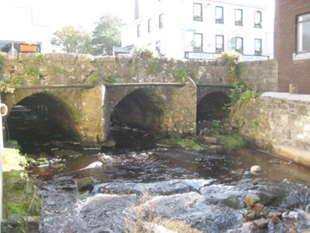 bridge19 yd
Explorer Tom Bridge in Dunglow has three arches that look like they’re wearing very serious stone smiles! Built around 1760, I wonder if the masons practiced their grins before setting each block. It feels like a river gatekeeper who’s been holding its breath for centuries.
 Bridge InnPub · 35 yd
Explorer Tom Bridge Inn in Dungloe claims to be on a bridge, but it might just be a big wooden box pretending. The bridge is probably wobbly and haunted by old fishermen. See if you can hear splashing indoors.
 Teach Leanna BeedíPub · 90 yd
Explorer Tom Teach Leanna Beedí is another fancy Irish name for a pub that likely serves mediocre beer. It’s right next door to Mulhern's, so the rivalry must be fierce. Check if they throw peanuts across the boundary.
 Bank of IrelandBank/financial institution · 113 yd
Explorer Tom The Dunglow Bank of Ireland has three pedimented half-dormers with fluted pilasters, looking very grand on An tSráid Mhór.
 Children's playground557 ydComputer-made picture. It does not show this playground.
Explorer Tom Dream of a Children's playground in County Donegal where the seesaws float gently on air, defying gravity for giggling children and wide-eyed adults.
 CroaghnamaddyMountain / peak · 2.5 mi
Explorer Tom Croaghnamaddy offers a whole view from County Donegal, a peak that seems to be keeping its secrets very closely.
 Lough Aghnish Promontory FortPromontory fort, inland · 3.4 mi
Explorer Tom Lough Aghnish Promontory Fort cuts off a peninsula with a stone wall that has a weird, angled entrance. The base is solid, but the top looks like modern repairs. It’s a bit of a puzzle why they built it exactly there.
 Drumlaghdrid HillMountain / peak · 3.9 mi
Explorer Tom Drumlaghdrid Hill stands in County Donegal with its access details currently unknown. A photograph shows the B7905 road climbing south-eastwards across its flank, six kilometres north of Lettermacaward. It is a bit cheeky for a hill to have such a well-documented road climbing up its side while still keeping its own path a secret!
 Inis Mhic an DoirnIsland · 4.2 mi
Explorer Tom Inis Mhic an Doirn is near Rutland Island in County Donegal, part of the Eighter group with historic ferry connections.
 Cairn, LoughanurePublicly named cairn · 4.3 mi
Explorer Tom Cairn, Loughanure sounds like a giant pile of stones that decided to take a nap. Maybe it’s actually a sleeping dragon that just hasn’t woken up yet.
 Hook Point / Pointe an DuáinHeadland · 4.5 mi
Explorer Tom Hook Point, or Pointe an Duáin, curls around the water like a friendly wave, waiting for you to take a peek.
 An tÍochtarIsland · 5.2 mi
Explorer Tom Eighter Island looks like the perfect coastal playground for a long walk, and I would have loved to be dropped off here.
What do you know about this place?Tap to add a comment or ask a question