What is recorded here
From OpenStreetMap (© OpenStreetMap contributors) n9491437434
Places near here
Photo credits
- Paucabot, Wikimedia Commons · CC BY-SA 3.0
- National Inventory of Architectural Heritage
- Ronan Mac Giollapharaic, Wikimedia Commons · CC BY-SA 4.0
- Guilhem Boyer, Wikimedia Commons · CC BY-SA 3.0
- Tom Pullman, Wikimedia Commons · CC BY-SA 2.0
- Gordon Hatton, Wikimedia Commons · CC BY-SA 2.0
- Gordon Hatton, Geograph · CC BY-SA 2.0
- Herbert Ortner, Wikimedia Commons · CC BY 3.0
- Marathon, Geograph · CC BY-SA 2.0
 harbour/dock/port399 yd
Explorer Tom Harbour in Killeany was built by two engineers who probably fought over who named the quays. It’s got three piers and zero patience for tourists who drop chips on the stone. Hang around long enough and you'll smell the old fish.
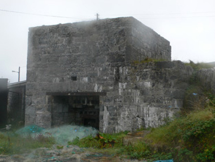 kiln435 yd
Explorer Tom Kiln in Killeany is where a local guy claims he invented lime, which is a bold lie for a stone oven on an island. It sat right by the harbour, bagging up dust for the rest of Árainn. Bring wellies and pretend you're mining gold.
 Arkin's CastleCastle · 569 yd
 St. Eanys WellHoly well · 665 yd
Explorer Tom St. Eanys Well in Cill Éinne has a drystone roof and a modern cross, looking very serious. Visit, then text me what you think. I'll pretend to read it while sipping tea.
 Teampall BheanáinHeritage attraction · 841 yd
 DoocaherPromontory fort, coastal · 1.4 mi
Explorer Tom Doocaher in Cill Éinne is sick of being asked if it’s haunted because it’s just really windy up there on that cliff top. It’s not ghosts, mate, it’s just the Atlantic being dramatic about its existence. Ten minutes here and you'll have a yarn for the pub.
 Dún EochlaHeritage attraction · 2.5 mi
 Dún ConchúirFort · 2.9 mi
 Inis MeáinIsland · 3.0 mi
 ÁrainnIsland · 3.3 mi
 Seal Colony LookoutViewpoint · 3.4 mi
 The Fir Bolg: Dún AonghasaLegend location · 4.9 mi
Explorer Tom The Fir Bolg: Dún Aonghasa has a mighty stone fort and a name tied to their leader Aonghas. If I had a fort named after me, I would be unbearable about it for years. The real walls are impressive enough; the name brings the Fir Bolg tale along for the ride.
More viewpoints and information in County Galway · All of County Galway

What do you know about this place?Tap to add a comment or ask a question